ଖୋଜା ଫଳାଫଳ
ଆପଣ kanhar district ଭାବି ଖୋଜିଥିଲେ କି?
"Kangra district" ନାମରେ ପ୍ରସଙ୍ଗଟିଏ ଏହି ଉଇକିରେ ଗଢ଼ନ୍ତୁ! ମିଳିଥିବା ଖୋଜା ଫଳାଫଳ ଦେଖନ୍ତୁ ।
- Imperial Gazetteer of India, v. 8, p. 233. "Part I: Kangra (1883-1884)", Gazetteer of the Kangra District, 1883-84; reprinted Indus Publ. [୧] Indian Princely...୬ KB (୩୧୨ ଟି ଶବ୍ଦ) - ୧୮:୨୮, ୧୭ ଡିସେମ୍ବର ୨୦୨୨
 Publishing, ISBN 81-7387-157-4, ... situated on a ridge called Kali dhar in Kangra district. It is built in the mandap (dome) style and the interior consists of...୧୧ KB (୭୪୨ ଟି ଶବ୍ଦ) - ୨୦:୧୦, ୮ ଅପ୍ରେଲ ୨୦୨୩
- (Kumarwah Lake) करेरी ङल ଫାଇଲ:Kareri Lake.JPG Kareri Lake ଅବସ୍ଥାନ Kangra district ଦିଗବାରେଣି 32°19′32″N 76°16′26″E / 32.325538°N 76.273818°E / 32.325538;...୩ KB (୧୧୭ ଟି ଶବ୍ଦ) - ୧୩:୫୬, ୧୫ ଫେବୃଆରୀ ୨୦୨୨
- Nalhati station of Birbhum district, West Bengal, India Vocal chord with part of the tracheae Kalika Devi Yogesh 46 Karnat, Kangra, himachalpradesh. Both...୧୬ KB (୨୯୩ ଟି ଶବ୍ଦ) - ୧୫:୫୯, ୩ ଜାନୁଆରୀ ୨୦୨୪
- North India Country India State Himachal Pradesh Region North India District Kangra Elevation 1,472 m (4,829 ft) Population • Total ୩,୫୪୩ Time zone UTC+5:30...୫ KB (୧୫୨ ଟି ଶବ୍ଦ) - ୧୨:୨୪, ୮ ଅକ୍ଟୋବର ୨୦୨୩
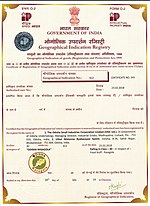 ହସ୍ତତନ୍ତ୍ର କର୍ଣ୍ଣାଟକ ୨୩ ୨୪ Mysore Rosewood Inlay ହସ୍ତତନ୍ତ୍ର କର୍ଣ୍ଣାଟକ ୨୪ ୨୫ Kangra Tea କୃଷି ହିମାଞ୍ଚଳ ପ୍ରଦେଶ ୨୫ ୨୬ Coimbatore Wet Grinder ଉତ୍ପାଦନ ତାମିଲ ନାଡୁ...୪୧ KB (୨୯୩ ଟି ଶବ୍ଦ) - ୦୮:୩୮, ୯ ଅକ୍ଟୋବର ୨୦୨୩
 field at Dharamkot near Dharamshala Country India State Himachal Pradesh District Kangra Elevation 2,100 m (6,900 ft) Languages Time zone UTC+5:30 (IST)...୪ KB (୧୨୦ ଟି ଶବ୍ଦ) - ୧୭:୧୦, ୧୭ ଡିସେମ୍ବର ୨୦୨୨


Discover data on the topic
Kangra district: District in Himachal Pradesh, India