ଫାଇଲ:Seto-Inland-Sea-Photo.jpg
ଏହି ଦେଖଣାର ଆକାର: ୮୦୦ × ୫୬୫ ପିକ୍ସେଲ । ବାକି ରେଜୋଲୁସନ: ୩୨୦ × ୨୨୬ ପିକ୍ସେଲ | ୬୪୦ × ୪୫୨ ପିକ୍ସେଲ | ୧,୦୨୪ × ୭୨୩ ପିକ୍ସେଲ | ୧,୨୮୦ × ୯୦୪ ପିକ୍ସେଲ | ୧,୭୦୦ × ୧,୨୦୦ ପିକ୍ସେଲ.
ମୂଳ ଫାଇଲ (୧,୭୦୦ × ୧,୨୦୦ ପିକସେଲ, ଫାଇଲ ଆକାର: ୯୪୫ KB, ଏମ.ଆଇ.ଏମ.ଇର ପ୍ରକାର: image/jpeg)
This is a file from the Wikimedia Commons. Information from its description page there is shown below. |
ସାରକଥା
| ବିବରଣୀ |
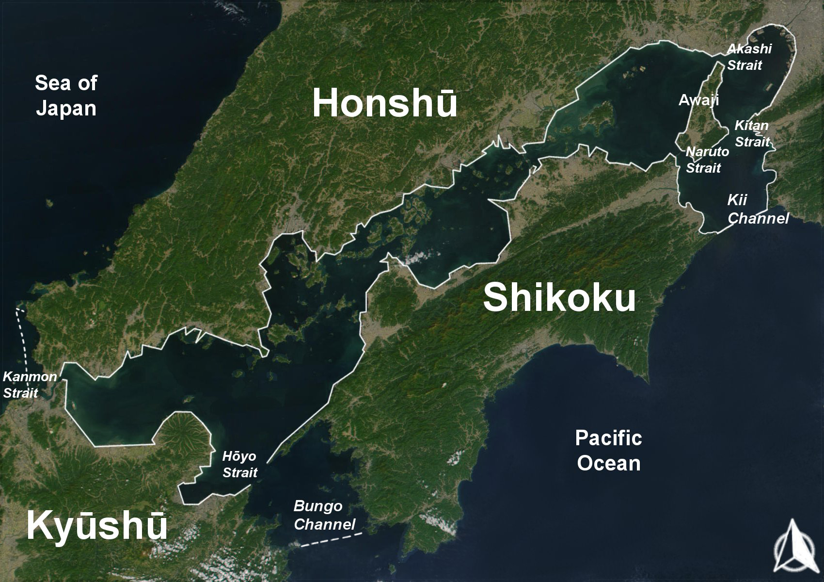
English: The Range of the Seto Inland Sea by the Territorial Sea Law (領海及び接続水域に関する法律) is 19,700 km2 (solid lines). Reference: Seto_Inland_Sea01.png . The Range of the Seto Inland Sea according to the Setouchi Law and the Setouchi Law Enforcement Order is 21,827 km2 (solid lines and dashed lines). Reference: Seto_Inland_Sea02.png.
Español: Mar interior de Seto. Extensión del Mar Interior |
| ତାରିଖ | |
| ମୂଳାଧାର | Based on a Public-Domain-Satellite photo of NASA |
| ଲେଖକ | User:Guenny (Christian Günther) made this map of the Japanese Inland Sea (Setonaikai,瀬戸内海) for the German Wikipedia. de:Seto-Inlandsee. It's showing the Japanese islands surrounding the sea with the major straits and channels. Guenny is willing to do translations to other languages if needed, as well as corrections and enhancements. |

|
ମାଗଣା ସଫ୍ଟବେର ଫାଉଣ୍ଡେସନ ଦେଇ ପ୍ରକାଶିତ କୌଣସି ବଦଳାଇ ନହେବା ଭଳି ଧାରା, ଆଗ ବା ପଛ ପଟ ମଲାଟ ବିନା GNU ଖୋଲା ଦଲିଲକାରଣ ଲାଇସେନ୍ସ ୧.୨ ତମ ସଙ୍କଳନ ବା ଆଉ କୌଣସି ସର୍ତ୍ତାବଳି ଅନୁସାରେ ଏହି ଦଲିଲର ନକଲ, ବଣ୍ଟନ ତଥା/କିମ୍ବା ବଦଳାଇବା ନିମନ୍ତେ ଅନୁମତି ଦିଆଗଲା । GNU ମାଗଣା ଦଲିଲକରଣ ଲାଇସେନ୍ସ ନାମକ ବିଭାଗରେ ଲାଇସେନ୍ସର ନକଲ ଦିଆଯାଇଅଛି । |
| ଏହି ଫାଇଲଟି କ୍ରିଏଟିଭ କମନ୍ସ ଅଧୀନରେ ଆଟ୍ରିବୁସନ ସେଆର-ଏଲାଇକ ୩.୦ ଅନପୋର୍ଟେଡ଼ ଲାଇସେନ୍ସରେ ପଞ୍ଜିକରଣ କରାଯାଇଅଛି । | ||
| ||
| GFDL ଲାଇସେନ୍ସ ଅପଡେଟର ଏକ ଭାଗ ଭାବରେ ଏହି ଲାଇସେନ୍ସ ଚିହ୍ନଟି ଏହି ଫାଇଲରେ ଯୋଡ଼ା ଯାଇଥିଲା । |
ଫାଇଲ ଇତିହାସ
ଏହା ଫାଇଲଟି ସେତେବେଳେ ଯେମିତି ଦିଶୁଥିଲା ତାହା ଦେଖିବା ପାଇଁ ତାରିଖ/ବେଳା ଉପରେ କ୍ଲିକ କରନ୍ତୁ
| ତାରିଖ/ବେଳ | ନଖ ଦେଖଣା | ଆକାର | ବ୍ୟବହାରକାରୀ | ମତାମତ | |
|---|---|---|---|---|---|
| ଏବେକାର | ୧୬:୧୩, ୧୧ ଅଗଷ୍ଟ ୨୦୧୯ | | ୧,୭୦୦ × ୧,୨୦୦ (୯୪୫ KB) | Artanisen | Added white solid lines for Kii Channel. |
| ୧୬:୦୨, ୧୧ ଅଗଷ୍ଟ ୨୦୧୯ |  | ୧,୭୦୦ × ୧,୨୦୦ (୯୪୧ KB) | Artanisen | Corrected white lines. The Range of the Seto Inland Sea by the Territorial Sea Law is 19,700 km2 (solid lines). Reference: Seto_Inland_Sea01.png . The Range of the Seto Inland Sea according to the Setouchi Law and the Setouchi Law Enforcement Order is 21,827 km2 (solid lines and dashed lines). Reference: Seto_Inland_Sea02.png . | |
| ୦୦:୪୮, ୧୯ ନଭେମ୍ବର ୨୦୦୪ |  | ୧,୭୦୦ × ୧,୨୦୦ (୩୨୬ KB) | Christian Dobrinoff | {{GFDL}} |
ଫାଇଲ ବ୍ୟବହାର
ଏହି ସବୁପୃଷ୍ଠା ଏହି ଫାଇଲଟିକୁ ଯୋଡ଼ିଥାନ୍ତି:
ଜଗତ ଫାଇଲ ବ୍ୟବହାର
ତଳଲିଖିତ ଉଇକିସବୁ ଏହି ଫାଇଲଟିକୁ ବ୍ୟବହାର କରିଥାନ୍ତି:
- an.wikipedia.orgରେ ବ୍ୟବହାର
- ar.wikipedia.orgରେ ବ୍ୟବହାର
- ast.wikipedia.orgରେ ବ୍ୟବହାର
- avk.wikipedia.orgରେ ବ୍ୟବହାର
- azb.wikipedia.orgରେ ବ୍ୟବହାର
- az.wikipedia.orgରେ ବ୍ୟବହାର
- bn.wikipedia.orgରେ ବ୍ୟବହାର
- br.wikipedia.orgରେ ବ୍ୟବହାର
- bs.wikipedia.orgରେ ବ୍ୟବହାର
- ca.wikipedia.orgରେ ବ୍ୟବହାର
- cs.wikipedia.orgରେ ବ୍ୟବହାର
- da.wikipedia.orgରେ ବ୍ୟବହାର
- de.wikipedia.orgରେ ବ୍ୟବହାର
- el.wikipedia.orgରେ ବ୍ୟବହାର
- en.wikipedia.orgରେ ବ୍ୟବହାର
- en.wiktionary.orgରେ ବ୍ୟବହାର
- eo.wikipedia.orgରେ ବ୍ୟବହାର
- es.wikipedia.orgରେ ବ୍ୟବହାର
- et.wikipedia.orgରେ ବ୍ୟବହାର
- eu.wikipedia.orgରେ ବ୍ୟବହାର
- fa.wikipedia.orgରେ ବ୍ୟବହାର
- fi.wikipedia.orgରେ ବ୍ୟବହାର
- fr.wikipedia.orgରେ ବ୍ୟବହାର
- fy.wikipedia.orgରେ ବ୍ୟବହାର
- gl.wikipedia.orgରେ ବ୍ୟବହାର
- he.wikipedia.orgରେ ବ୍ୟବହାର
- hr.wikipedia.orgରେ ବ୍ୟବହାର
- hu.wikipedia.orgରେ ବ୍ୟବହାର
- id.wikipedia.orgରେ ବ୍ୟବହାର
- is.wikipedia.orgରେ ବ୍ୟବହାର
- it.wikipedia.orgରେ ବ୍ୟବହାର
ଏହି ଫାଇଲଟିର ଅଧିକ ବିଶ୍ୱବ୍ୟାପୀ ବ୍ୟବହାର ଦେଖନ୍ତୁ ।