ଫାଇଲ:Map Canada political-geo.png

ମୂଳ ଫାଇଲ (୧,୨୮୦ × ୧,୧୨୮ ପିକସେଲ, ଫାଇଲ ଆକାର: ୪୯୨ KB, ଏମ.ଆଇ.ଏମ.ଇର ପ୍ରକାର: image/png)
This is a file from the Wikimedia Commons. Information from its description page there is shown below. |
ସାରକଥା
| ବିବରଣୀ |
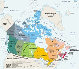
Map: Canada – geopolitical Drawn and adapted by E Pluribus Anthony from Atlas of Canada Edited by en:User:Heqs/en:User:Cogito ergo sumo to show disputed nature of Canada's marine international boundary claims; see en:Canada-United_States_border#Remaining_boundary_disputes; further edited by Bosonic dressing to reflect agreed maritime boundary between Canada and Greenland/Denmark: see http://www.dur.ac.uk/resources/ibru/arctic.pdf |
| ତାରିଖ | ୧୧ ମାର୍ଚ୍ଚ ୨୦୦୬ (original upload date) |
| ମୂଳାଧାର | Originally from en.wikipedia; description page is/was here. |
| ଲେଖକ |
Original uploader was E Pluribus Anthony at en.wikipedia Later versions were uploaded by AThing, Heqs, Cogito ergo sumo at en.wikipedia. |
| ଅନୁମତି (ଏହି ଫାଇଲକୁ ପୁଣି ବ୍ୟବହାର କରିବେ) |
Released into the public domain (by the author). |
| ଅନ୍ୟ ସଂସ୍କରଣ | Derivative works of this file: Map Canada political-geo-be-x-old.png |
ସତ୍ଵ
| |
ଏହି କାମଟି ପବ୍ଲିକ ଡୋମେନ ରେ ଏହାର ଗଢ଼ାଳିE Pluribus Anthony, at the ଇଂରାଜୀ ଉଇକିପିଡ଼ିଆ projectଙ୍କ ଦେଇ ପ୍ରକାଶିତ ହେଲା, ଏହା ଜଗତସାରା ଲାଗୁ । In case this is not legally possible: |
ଫାଇଲ ଇତିହାସ
ଏହା ଫାଇଲଟି ସେତେବେଳେ ଯେମିତି ଦିଶୁଥିଲା ତାହା ଦେଖିବା ପାଇଁ ତାରିଖ/ବେଳା ଉପରେ କ୍ଲିକ କରନ୍ତୁ
| ତାରିଖ/ବେଳ | ନଖ ଦେଖଣା | ଆକାର | ବ୍ୟବହାରକାରୀ | ମତାମତ | |
|---|---|---|---|---|---|
| ଏବେକାର | ୧୩:୦୭, ୮ ନଭେମ୍ବର ୨୦୦୮ | | ୧,୨୮୦ × ୧,୧୨୮ (୪୯୨ KB) | Bosonic dressing | {{Information |Description=Map of Canada, revised to reflect agreed border with Greenland/Denmark, per http://www.dur.ac.uk/resources/ibru/arctic.pdf |Source= |Date=8 November 2008 |Author=E Pluribus Anthony, et al |Permission= |other_versions= }} |
| ୧୩:୦୩, ୮ ନଭେମ୍ବର ୨୦୦୮ |  | ୧,୨୮୦ × ୧,୨୯୭ (୫୨୯ KB) | Bosonic dressing | {{Information |Description=Map of Canada, revised to reflect agreed border with Greenland/Denamrk, per http://www.dur.ac.uk/resources/ibru/arctic.pdf |Source= |Date=8 November 2008 |Author=E Pluribus Anthony, et al |Permission= |other_versions= }} | |
| ୦୧:୨୪, ୧୬ ଜୁନ ୨୦୦୭ |  | ୧,୨୮୦ × ୧,୧୨୮ (୪୯୬ KB) | PMG | {{Information |Description=Map: en:Canada – geopolitical Drawn and adapted by E Pluribus Anthony from [http://atlas.gc.ca/site/english/maps/reference/national/can_political_e Atlas of Canada] Edited by [[:en:User:H |
ଫାଇଲ ବ୍ୟବହାର
ଏହି ଫାଇଲ ସହିତ ଯୋଡ଼ା ଗୋଟିଏ ବି ପୃଷ୍ଠା ନାହିଁ ।
ଜଗତ ଫାଇଲ ବ୍ୟବହାର
ତଳଲିଖିତ ଉଇକିସବୁ ଏହି ଫାଇଲଟିକୁ ବ୍ୟବହାର କରିଥାନ୍ତି:
- ace.wikipedia.orgରେ ବ୍ୟବହାର
- ar.wikipedia.orgରେ ବ୍ୟବହାର
- cu.wikipedia.orgରେ ବ୍ୟବହାର
- cy.wikipedia.orgରେ ବ୍ୟବହାର
- da.wikipedia.orgରେ ବ୍ୟବହାର
- de.wikipedia.orgରେ ବ୍ୟବହାର
- de.wikivoyage.orgରେ ବ୍ୟବହାର
- en.wikipedia.orgରେ ବ୍ୟବହାର
- Talk:Ottawa
- Talk:Montreal
- Talk:Toronto
- Talk:Whatì
- Talk:Brampton
- Talk:Emerald Park, Saskatchewan
- Wikipedia talk:WikiProject Toronto
- Talk:St. John's, Newfoundland and Labrador
- Talk:North Bay, Ontario
- Talk:List of communities in Quebec
- Talk:Saguenay, Quebec
- Talk:List of cities in Canada
- Talk:Carleton Place
- Talk:London, Ontario
- Talk:St. Catharines
- Talk:Etobicoke
- Talk:Inuvik
- Talk:Tulita
- Talk:Surrey, British Columbia
- Talk:Montreal, Quebec
- Talk:100 Mile House
- Talk:Timmins
- Talk:Mississauga/Archive 2
- Talk:King, Ontario
- Talk:Medicine Hat
- Talk:Bramalea, Ontario
- Talk:Elliot Lake
- Index of Canada-related articles
- Talk:List of unincorporated communities in Ontario
- Talk:Vancouver
- Talk:Coquitlam
- Talk:Regent Park
- Talk:The Peanut
- Talk:List of the largest municipalities in Canada by population
- Talk:Thornhill, Ontario
- Talk:Kitchener, Ontario
ଏହି ଫାଇଲଟିର ଅଧିକ ବିଶ୍ୱବ୍ୟାପୀ ବ୍ୟବହାର ଦେଖନ୍ତୁ ।