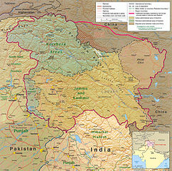
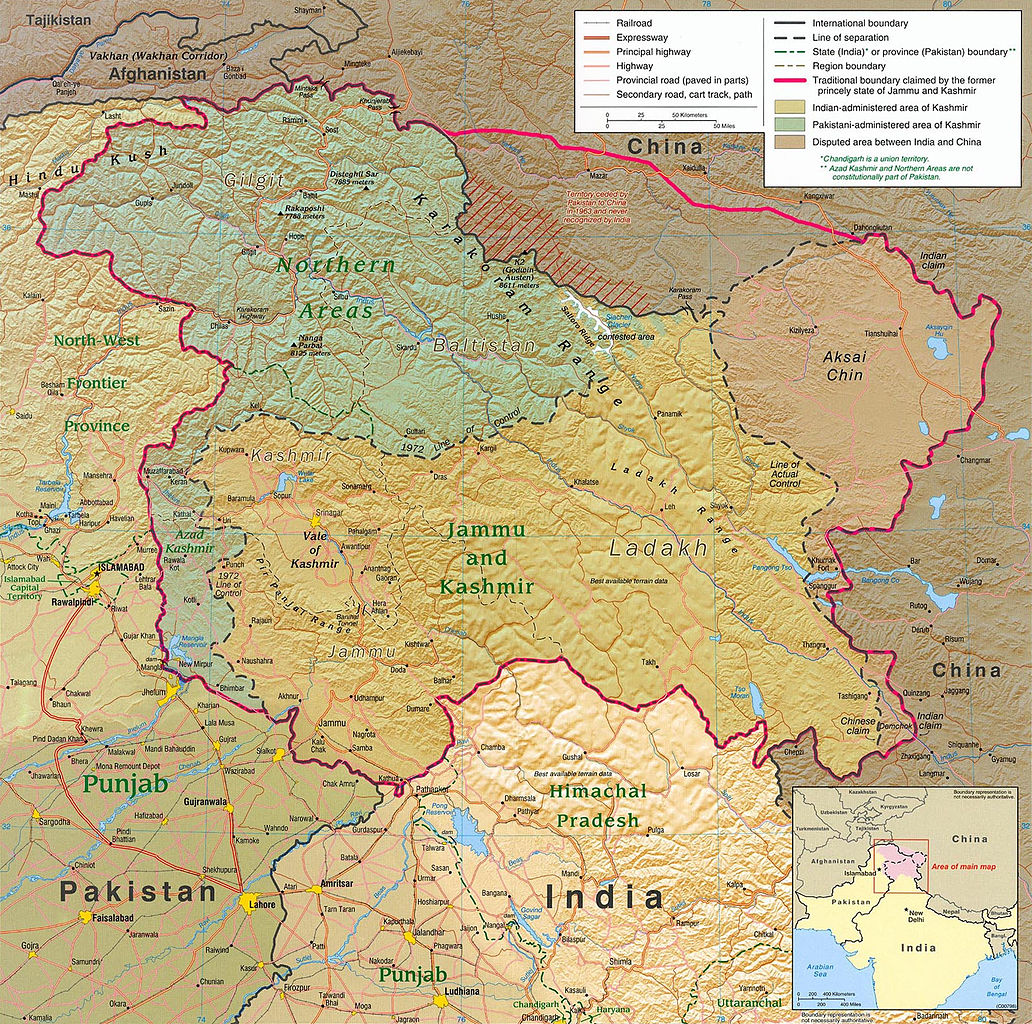
ଫାଇଲ:Kashmir region 2004.jpg

ଏହି ଦେଖଣାର ଆକାର: ୬୦୪ × ୫୯୯ ପିକ୍ସେଲ । ବାକି ରେଜୋଲୁସନ: ୨୪୨ × ୨୪୦ ପିକ୍ସେଲ | ୪୮୪ × ୪୮୦ ପିକ୍ସେଲ | ୭୭୪ × ୭୬୮ ପିକ୍ସେଲ | ୧,୦୩୨ × ୧,୦୨୪ ପିକ୍ସେଲ | ୧,୫୭୯ × ୧,୫୬୭ ପିକ୍ସେଲ.
ମୂଳ ଫାଇଲ (୧,୫୭୯ × ୧,୫୬୭ ପିକସେଲ, ଫାଇଲ ଆକାର: ୧.୭୧ MB, ଏମ.ଆଇ.ଏମ.ଇର ପ୍ରକାର: image/jpeg)
This is a file from the Wikimedia Commons. Information from its description page there is shown below. |
| ବିବରଣୀ |
English: Kashmir Region 2004 |
|||
| ତାରିଖ | ||||
| ମୂଳାଧାର | http://www.lib.utexas.edu/maps/middle_east_and_asia/kashmir_region_2004.jpg | |||
| ଲେଖକ | CIA | |||
| ଅନୁମତି (ଏହି ଫାଇଲକୁ ପୁଣି ବ୍ୟବହାର କରିବେ) |
|
|||
| ଅନ୍ୟ ସଂସ୍କରଣ |
 .jpg)
|


ଫାଇଲ ଇତିହାସ
ଏହା ଫାଇଲଟି ସେତେବେଳେ ଯେମିତି ଦିଶୁଥିଲା ତାହା ଦେଖିବା ପାଇଁ ତାରିଖ/ବେଳା ଉପରେ କ୍ଲିକ କରନ୍ତୁ
| ତାରିଖ/ବେଳ | ନଖ ଦେଖଣା | ଆକାର | ବ୍ୟବହାରକାରୀ | ମତାମତ | |
|---|---|---|---|---|---|
| ଏବେକାର | ୦୩:୧୫, ୭ ଜୁନ ୨୦୧୦ | | ୧,୫୭୯ × ୧,୫୬୭ (୧.୭୧ MB) | Ras67 | slightly rotated and cropped |
| ୦୦:୧୬, ୮ ମାର୍ଚ୍ଚ ୨୦୦୬ |  | ୧,୬୧୬ × ୧,୬୨୩ (୭୮୯ KB) | Jungpionier | Kashmir Region 2004 Source URL: [http://www.lib.utexas.edu/maps/middle_east_and_asia/kashmir_region_2004.jpg]. {{PD-USGov-CIA}} |
ଫାଇଲ ବ୍ୟବହାର
ଏହି ସବୁ2 ପୃଷ୍ଠାସବୁ ଏହି ଫାଇଲଟିକୁ ଯୋଡ଼ିଥାନ୍ତି:
ଜଗତ ଫାଇଲ ବ୍ୟବହାର
ତଳଲିଖିତ ଉଇକିସବୁ ଏହି ଫାଇଲଟିକୁ ବ୍ୟବହାର କରିଥାନ୍ତି:
- af.wikipedia.orgରେ ବ୍ୟବହାର
- ang.wikipedia.orgରେ ବ୍ୟବହାର
- ar.wikipedia.orgରେ ବ୍ୟବହାର
- arz.wikipedia.orgରେ ବ୍ୟବହାର
- azb.wikipedia.orgରେ ବ୍ୟବହାର
- az.wikipedia.orgରେ ବ୍ୟବହାର
- be-tarask.wikipedia.orgରେ ବ୍ୟବହାର
- be.wikipedia.orgରେ ବ୍ୟବହାର
- bg.wikipedia.orgରେ ବ୍ୟବହାର
- bh.wikipedia.orgରେ ବ୍ୟବହାର
- bn.wikipedia.orgରେ ବ୍ୟବହାର
- br.wikipedia.orgରେ ବ୍ୟବହାର
- ca.wikipedia.orgରେ ବ୍ୟବହାର
- cdo.wikipedia.orgରେ ବ୍ୟବହାର
- ckb.wikipedia.orgରେ ବ୍ୟବହାର
- cs.wikipedia.orgରେ ବ୍ୟବହାର
- da.wikipedia.orgରେ ବ୍ୟବହାର
- de.wikipedia.orgରେ ବ୍ୟବହାର
- de.wikinews.orgରେ ବ୍ୟବହାର
- diq.wikipedia.orgରେ ବ୍ୟବହାର
- el.wikipedia.orgରେ ବ୍ୟବହାର
- en.wikipedia.orgରେ ବ୍ୟବହାର
ଏହି ଫାଇଲଟିର ଅଧିକ ବିଶ୍ୱବ୍ୟାପୀ ବ୍ୟବହାର ଦେଖନ୍ତୁ ।