ଫାଇଲ:Irland karte.png
ମୂଳ ଫାଇଲ (୧,୪୭୩ × ୧,୭୫୭ ପିକସେଲ, ଫାଇଲ ଆକାର: ୧.୨୫ MB, ଏମ.ଆଇ.ଏମ.ଇର ପ୍ରକାର: image/png)
This is a file from the Wikimedia Commons. Information from its description page there is shown below. |
|
| ବିବରଣୀ |
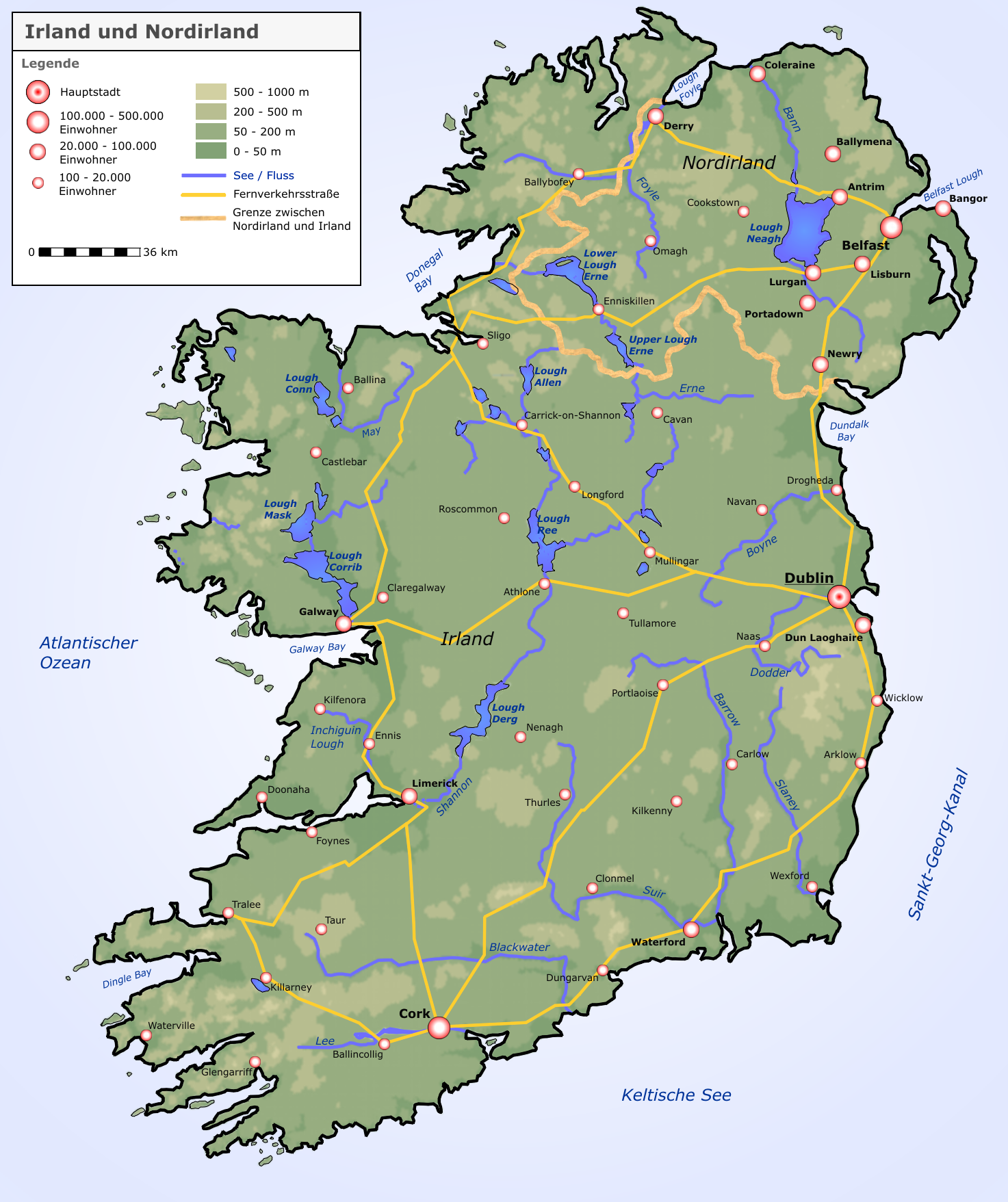
Deutsch: Neue Karte von Irland und Nordirland |
| ତାରିଖ | |
| ମୂଳାଧାର |
selbst erstellt von Roger Zenner
|
| ଲେଖକ | Roger Zenner |
| ଅନୁମତି (ଏହି ଫାଇଲକୁ ପୁଣି ବ୍ୟବହାର କରିବେ) |
CC-by-sa-2.0-de |
| ଅନ୍ୟ ସଂସ୍କରଣ |
copied from de.wikipedia [1]:
|
![[1]](https://de.wikipedia.org/wiki/Bild:Irland_karte.png)
- ଆପଣ ଆରାମରେ:
- ବାଣ୍ଟିପାରିବେ – କାମଟିକୁ ନକଲ କରିପାରିବେ, ବାଣ୍ଟିପାରିବେ ଓ ପ୍ରସାରଣ କରିପାରିବେ
- ମିଶାଇପାରିବେ – କାମଟି ଅଭିଯୋଜନ କରିପାରିବେ
- ତଳଲିଖିତ ସର୍ତ୍ତାବଳୀ ଅଧୀନରେ:
- ଶ୍ରେୟ – ଆପଣ ମନେ କରି ଏହି କାମର ଆବଶ୍ୟକୀୟ ଶ୍ରେୟ ମୂଳ ଗଢ଼ାଳି ବା ସ୍ୱତ୍ୱାଧୀକାରୀଙ୍କୁ ଦେବେ ଏବଂ ଦେଲାବେଳେ ଲାଇସେନ୍ସର ଲିଙ୍କ ଦେଇ କି କି ବଦଳ କଲେ ଉଲ୍ଲେଖ କରିବେ । ଏହା ଉପଯୁକ୍ତ ଢଙ୍ଗରେ କରିବେ କିନ୍ତୁ ଲାଇସେନ୍ସ ଦେଉଥିବା ବ୍ୟକ୍ତି ଆପଣଙ୍କ ପ୍ରଚାର କଲା ଭଳି କିଛି ଲେଖିବେ ନାହିଁ ।
- ସେଆର ଏଲାଇକ – ଯଦି ଆପଣ ଏହି କାମଟିକୁ ବଦଳାଇବେ, ରୂପାନ୍ତରଣ କରିବେ ବା ଏହାକୁ ନେଇ କିଛି ଗଢ଼ିବେ ତେବେ ଆପଣ ଏହାକୁ ଏକା ବା ଅଲଗା ଲାଇସେନ୍ସ ଭିତରେ ରଖିପାରିବେ ।


|
This map image could be re-created using vector graphics as an SVG file. This has several advantages; see Commons:Media for cleanup for more information. If an SVG form of this image is available, please upload it and afterwards replace this template with
{{vector version available|new image name}}.
It is recommended to name the SVG file “Irland karte.svg”—then the template Vector version available (or Vva) does not need the new image name parameter. |
ଫାଇଲ ଇତିହାସ
ଏହା ଫାଇଲଟି ସେତେବେଳେ ଯେମିତି ଦିଶୁଥିଲା ତାହା ଦେଖିବା ପାଇଁ ତାରିଖ/ବେଳା ଉପରେ କ୍ଲିକ କରନ୍ତୁ
| ତାରିଖ/ବେଳ | ନଖ ଦେଖଣା | ଆକାର | ବ୍ୟବହାରକାରୀ | ମତାମତ | |
|---|---|---|---|---|---|
| ଏବେକାର | ୧୪:୩୫, ୧୭ ସେପ୍ଟେମ୍ବର ୨୦୦୫ | | ୧,୪୭୩ × ୧,୭୫୭ (୧.୨୫ MB) | Saperaud~commonswiki | neue Karte von Irland und Nordirland Lizenz: Das Bild wurde von Benutzer:Roger_Zenner gezeichnet und wurde unter der CC-by-sa/2.0/de veröffentlicht. *Version 1.6: Höhenstufen weicher *Version 1.5: Londonderry heißt nun Derry, Beschriftungen angep |
ଫାଇଲ ବ୍ୟବହାର
ଏହି ଫାଇଲ ସହିତ ଯୋଡ଼ା ଗୋଟିଏ ବି ପୃଷ୍ଠା ନାହିଁ ।
ଜଗତ ଫାଇଲ ବ୍ୟବହାର
ତଳଲିଖିତ ଉଇକିସବୁ ଏହି ଫାଇଲଟିକୁ ବ୍ୟବହାର କରିଥାନ୍ତି:
- ar.wikipedia.orgରେ ବ୍ୟବହାର
- ca.wikipedia.orgରେ ବ୍ୟବହାର
- cs.wikipedia.orgରେ ବ୍ୟବହାର
- da.wikipedia.orgରେ ବ୍ୟବହାର
- de.wikipedia.orgରେ ବ୍ୟବହାର
- Irland (Insel)
- Irland
- Wikipedia:Kandidaten für exzellente Bilder/Archiv2004/4
- Benutzer:Roger Zenner/Bilder
- Datei:Irland karte.png
- Benutzer:Cmoder/Grafiktipps
- Wikipedia:Exzellente Bilder/Karten und Satellitenbilder
- Benutzer:Uwe Dedering/Länderliste
- Benutzer:Ulflulfl/Karten
- Vorlage:Infobox Insel/Erprobung Karte in einer Ecke
- Vorlage:Infobox Insel/Erprobung Karte in einer Ecke/Doku
- de.wiktionary.orgରେ ବ୍ୟବହାର
- eo.wikipedia.orgରେ ବ୍ୟବହାର
- et.wikipedia.orgରେ ବ୍ୟବହାର
- frr.wikipedia.orgରେ ବ୍ୟବହାର
- fr.wikipedia.orgରେ ବ୍ୟବହାର
- ga.wikipedia.orgରେ ବ୍ୟବହାର
- hy.wikipedia.orgରେ ବ୍ୟବହାର
- kab.wikipedia.orgରେ ବ୍ୟବହାର
- lb.wikipedia.orgରେ ବ୍ୟବହାର
- pfl.wikipedia.orgରେ ବ୍ୟବହାର
- pl.wikipedia.orgରେ ବ୍ୟବହାର
- Shannon (rzeka)
- Geografia Irlandii
- Boyne
- Lee (rzeka w Irlandii)
- Wikipedysta:DodekBot/lista-de
- Wikipedysta:DodekBot/lista-de2
- Corrib
- Liffey
- Blackwater (Meath)
- Slaney
- Munster Blackwater
- Barrow (rzeka)
- Brosna (rzeka)
- Suir
- Nore
- Erne
- Camac
- Tolka
- Dodder
- Mulkear
- Laune
- Blackwater (Kerry)
- Blackwater (Ulster)
- Finn (rzeka)
ଏହି ଫାଇଲଟିର ଅଧିକ ବିଶ୍ୱବ୍ୟାପୀ ବ୍ୟବହାର ଦେଖନ୍ତୁ ।