ଫାଇଲ:Gibraltar map-en-edit2.svg

ମୂଳ ଫାଇଲ (SVG ଫାଇଲ, ସାଧାରଣ ମାପ ୧,୦୦୦ × ୧,୫୫୮ ପିକ୍ସେଲ, ଫାଇଲ ଆକାର: ୧.୪୬ MB)
This is a file from the Wikimedia Commons. Information from its description page there is shown below. |
ସାରକଥା
|
| Camera location | | View this and other nearby images on: OpenStreetMap |
|---|
| ବିବରଣୀ |
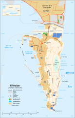
English: Map in English of Gibraltar
Français : Carte en anglais de Gibraltar |
| ତାରିଖ | |
| ମୂଳାଧାର |
English: adapted from: Image:Gibraltar map-en.svg
Français : Création personnelle ;
|
| ଲେଖକ | Original by Eric Gaba (Sting), label/legend edits by Jeff Dahl |
| ଅନୁମତି (ଏହି ଫାଇଲକୁ ପୁଣି ବ୍ୟବହାର କରିବେ) |
Attribution and Share-Alike required |
| ଅନ୍ୟ ସଂସ୍କରଣ |
|


|
This SVG file contains embedded text that can be translated into your language, using any capable SVG editor, text editor or the SVG Translate tool. For more information see: About translating SVG files. |
ସତ୍ଵ

|
ମାଗଣା ସଫ୍ଟବେର ଫାଉଣ୍ଡେସନ ଦେଇ ପ୍ରକାଶିତ କୌଣସି ବଦଳାଇ ନହେବା ଭଳି ଧାରା, ଆଗ ବା ପଛ ପଟ ମଲାଟ ବିନା GNU ଖୋଲା ଦଲିଲକାରଣ ଲାଇସେନ୍ସ ୧.୨ ତମ ସଙ୍କଳନ ବା ଆଉ କୌଣସି ସର୍ତ୍ତାବଳି ଅନୁସାରେ ଏହି ଦଲିଲର ନକଲ, ବଣ୍ଟନ ତଥା/କିମ୍ବା ବଦଳାଇବା ନିମନ୍ତେ ଅନୁମତି ଦିଆଗଲା । GNU ମାଗଣା ଦଲିଲକରଣ ଲାଇସେନ୍ସ ନାମକ ବିଭାଗରେ ଲାଇସେନ୍ସର ନକଲ ଦିଆଯାଇଅଛି । |
- ଆପଣ ଆରାମରେ:
- ବାଣ୍ଟିପାରିବେ – କାମଟିକୁ ନକଲ କରିପାରିବେ, ବାଣ୍ଟିପାରିବେ ଓ ପ୍ରସାରଣ କରିପାରିବେ
- ମିଶାଇପାରିବେ – କାମଟି ଅଭିଯୋଜନ କରିପାରିବେ
- ତଳଲିଖିତ ସର୍ତ୍ତାବଳୀ ଅଧୀନରେ:
- ଶ୍ରେୟ – ଆପଣ ମନେ କରି ଏହି କାମର ଆବଶ୍ୟକୀୟ ଶ୍ରେୟ ମୂଳ ଗଢ଼ାଳି ବା ସ୍ୱତ୍ୱାଧୀକାରୀଙ୍କୁ ଦେବେ ଏବଂ ଦେଲାବେଳେ ଲାଇସେନ୍ସର ଲିଙ୍କ ଦେଇ କି କି ବଦଳ କଲେ ଉଲ୍ଲେଖ କରିବେ । ଏହା ଉପଯୁକ୍ତ ଢଙ୍ଗରେ କରିବେ କିନ୍ତୁ ଲାଇସେନ୍ସ ଦେଉଥିବା ବ୍ୟକ୍ତି ଆପଣଙ୍କ ପ୍ରଚାର କଲା ଭଳି କିଛି ଲେଖିବେ ନାହିଁ ।
- ସେଆର ଏଲାଇକ – ଯଦି ଆପଣ ଏହି କାମଟିକୁ ବଦଳାଇବେ, ରୂପାନ୍ତରଣ କରିବେ ବା ଏହାକୁ ନେଇ କିଛି ଗଢ଼ିବେ ତେବେ ଆପଣ ଏହାକୁ ଏକା ବା ଅଲଗା ଲାଇସେନ୍ସ ଭିତରେ ରଖିପାରିବେ ।
ଫାଇଲ ଇତିହାସ
ଏହା ଫାଇଲଟି ସେତେବେଳେ ଯେମିତି ଦିଶୁଥିଲା ତାହା ଦେଖିବା ପାଇଁ ତାରିଖ/ବେଳା ଉପରେ କ୍ଲିକ କରନ୍ତୁ
| ତାରିଖ/ବେଳ | ନଖ ଦେଖଣା | ଆକାର | ବ୍ୟବହାରକାରୀ | ମତାମତ | |
|---|---|---|---|---|---|
| ଏବେକାର | ୨୨:୦୬, ୫ ଅପ୍ରେଲ ୨୦୧୭ | | ୧,୦୦୦ × ୧,୫୫୮ (୧.୪୬ MB) | RaviC | + University, Ferry terminal (& Route), Cathedral |
| ୦୦:୨୨, ୧୨ ଡିସେମ୍ବର ୨୦୦୭ |  | ୧,୦୦୦ × ୧,୫୫୮ (୧.୭୯ MB) | Jeff Dahl | resized 1200 down to 1000px wide, minor label fixes | |
| ୨୨:୩୮, ୧୦ ଡିସେମ୍ବର ୨୦୦୭ |  | ୧,୨୦୦ × ୧,୮୭୦ (୧.୭୮ MB) | Jeff Dahl | {{inkscape}} {{Location|36|08|00|N|5|21|00|W|type:city_scale:50000}} {{Information |Description=Map in English of Gibraltar |Source=adapted from: Image:Gibraltar map-en.svg <br/>Map created using screenshots of [[:en:Google Ea |
ଫାଇଲ ବ୍ୟବହାର
ଏହି ସବୁପୃଷ୍ଠା ଏହି ଫାଇଲଟିକୁ ଯୋଡ଼ିଥାନ୍ତି:
ଜଗତ ଫାଇଲ ବ୍ୟବହାର
ତଳଲିଖିତ ଉଇକିସବୁ ଏହି ଫାଇଲଟିକୁ ବ୍ୟବହାର କରିଥାନ୍ତି:
- af.wikipedia.orgରେ ବ୍ୟବହାର
- ar.wikipedia.orgରେ ବ୍ୟବହାର
- av.wikipedia.orgରେ ବ୍ୟବହାର
- azb.wikipedia.orgରେ ବ୍ୟବହାର
- bg.wikipedia.orgରେ ବ୍ୟବହାର
- bn.wikipedia.orgରେ ବ୍ୟବହାର
- bs.wikipedia.orgରେ ବ୍ୟବହାର
- ceb.wikipedia.orgରେ ବ୍ୟବହାର
- Plantilya:Location map Gibraltar
- Signal Hill
- White Rock
- Sandy Bay
- Roca Blanca
- Ailsa Craig
- Passage Point
- El Peñón
- The Rock
- Middle Hill
- Gibraltar (pagklaro)
- Rock of Gibraltar
- Deadmans Beach
- Eastern Beach
- Western Beach
- Punta Pasaje
- Punta Europa
- La Roca
- Governor’s Beach
- Camp Bay
- Europa Point
- Gibraltar Bay
- Cerro de Enmedio
- Blackstrap Bay
- Caledonian Canal
- Great Europa Point
- Gibilterra
- White Rock (bato sa Gyibraltar)
- Western Beach (lapyahan sa Gyibraltar)
- Signal Hill (bungtod sa Gyibraltar)
- Sandy Bay North
- Sandy Bay (luuk)
- Saint Michael's Cave
- Saint Abb's Head
- North Gorge
- Middle Hill (bungtod sa Gyibraltar)
- Mediterranean Steps
- Martin's Cave
- Europa Point (punta sa Gyibraltar)
- The Lido
- Levant Cave
- H.M.S. Rooke
ଏହି ଫାଇଲଟିର ଅଧିକ ବିଶ୍ୱବ୍ୟାପୀ ବ୍ୟବହାର ଦେଖନ୍ତୁ ।