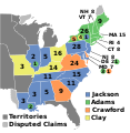
ଫାଇଲ:ElectoralCollege1824.svg

Size of this PNG preview of this SVG file: ୫୭୭ × ୫୯୩ ପିକ୍ସେଲ. ବାକି ରେଜୋଲୁସନ: ୨୩୪ × ୨୪୦ ପିକ୍ସେଲ | ୪୬୭ × ୪୮୦ ପିକ୍ସେଲ | ୭୪୭ × ୭୬୮ ପିକ୍ସେଲ | ୯୯୬ × ୧,୦୨୪ ପିକ୍ସେଲ | ୧,୯୯୩ × ୨,୦୪୮ ପିକ୍ସେଲ.
ମୂଳ ଫାଇଲ (SVG ଫାଇଲ, ସାଧାରଣ ମାପ ୫୭୭ × ୫୯୩ ପିକ୍ସେଲ, ଫାଇଲ ଆକାର: ୧୯୦ KB)
ଫାଇଲ ଇତିହାସ
ଏହା ଫାଇଲଟି ସେତେବେଳେ ଯେମିତି ଦିଶୁଥିଲା ତାହା ଦେଖିବା ପାଇଁ ତାରିଖ/ବେଳା ଉପରେ କ୍ଲିକ କରନ୍ତୁ
| ତାରିଖ/ବେଳ | ନଖ ଦେଖଣା | ଆକାର | ବ୍ୟବହାରକାରୀ | ମତାମତ | |
|---|---|---|---|---|---|
| ଏବେକାର | ୦୬:୦୩, ୧୮ ଜୁନ ୨୦୨୩ |  | ୫୭୭ × ୫୯୩ (୧୯୦ KB) | Rogl94 | Corrected Delaware and Maine |
| ୦୪:୦୪, ୧୨ ଜୁଲାଇ ୨୦୧୮ |  | ୫୭୭ × ୫୯୩ (୧୯୩ KB) | Wow | fix | |
| ୦୩:୧୯, ୧୨ ଜୁଲାଇ ୨୦୧୮ |  | ୫୭୭ × ୫୯୩ (୧୯୩ KB) | Wow | disputed claim | |
| ୦୭:୫୨, ୨୭ ଡିସେମ୍ବର ୨୦୧୬ |  | ୫୭୭ × ୫୯୩ (୧୧୨ KB) | Wow | Adams | |
| ୧୨:୨୭, ୧୪ ନଭେମ୍ବର ୨୦୧୬ |  | ୫୭୭ × ୫୯୩ (୧୧୨ KB) | Wow | Clay's states | |
| ୧୨:୨୪, ୧୪ ନଭେମ୍ବର ୨୦୧୬ |  | ୫୭୭ × ୫୯୩ (୧୧୨ KB) | Wow | Territories | |
| ୦୪:୨୫, ୧ ଅଗଷ୍ଟ ୨୦୧୬ |  | ୫୭୭ × ୫୯୩ (୧୧୨ KB) | Spartan7W | no need for entire continent when no states are further west than Missouri | |
| ୧୫:୧୭, ୧୮ ଅକ୍ଟୋବର ୨୦୧୧ |  | ୧,୦୨୦ × ୫୯୩ (୪୫ KB) | Fred the Oyster | optimise and try to correct render artifact | |
| ୦୭:୨୬, ୧ ଜାନୁଆରୀ ୨୦୦୯ |  | ୧,୦୨୦ × ୫୯୩ (୯୭ KB) | AndyHogan14 | {{Information |Description= |Source= |Date= |Author= |Permission= |other_versions= }} | |
| ୦୧:୨୪, ୧ ଜାନୁଆରୀ ୨୦୦୯ |  | ୧,୦୨୦ × ୫୯୩ (୯୭ KB) | AndyHogan14 | {{Information |Description= |Source= |Date= |Author= |Permission= |other_versions= }} |
ଫାଇଲ ବ୍ୟବହାର
ଏହି ଫାଇଲ ସହିତ ଯୋଡ଼ା ଗୋଟିଏ ବି ପୃଷ୍ଠା ନାହିଁ ।
ଜଗତ ଫାଇଲ ବ୍ୟବହାର
ତଳଲିଖିତ ଉଇକିସବୁ ଏହି ଫାଇଲଟିକୁ ବ୍ୟବହାର କରିଥାନ୍ତି:
- da.wikipedia.orgରେ ବ୍ୟବହାର
- de.wikipedia.orgରେ ବ୍ୟବହାର
- el.wikipedia.orgରେ ବ୍ୟବହାର
- en.wikipedia.orgରେ ବ୍ୟବହାର
- John Quincy Adams
- Democratic-Republican Party
- 1824 United States presidential election
- Corrupt bargain
- Electoral vote changes between United States presidential elections
- List of United States presidential election results by state
- Presidency of James Monroe
- Presidency of John Quincy Adams
- 1824 United States presidential election in Missouri
- United States presidential election
- Wikipedia:Graphics Lab/Illustration workshop/Archive/Nov 2011
- 1824 United States presidential election in Pennsylvania
- 1824 United States presidential election in Alabama
- 1824 United States presidential election in Connecticut
- 1824 United States presidential election in Illinois
- 1824 United States presidential election in Indiana
- 1824 United States presidential election in Kentucky
- 1824 United States presidential election in Maine
- 1824 United States presidential election in Maryland
- 1824 United States presidential election in Massachusetts
- 1824 United States presidential election in Mississippi
- 1824 United States presidential election in New Hampshire
- 1824 United States presidential election in New Jersey
- 1824 United States presidential election in North Carolina
- 1824 United States presidential election in Ohio
- 1824 United States presidential election in Rhode Island
- 1824 United States presidential election in Tennessee
- 1824 United States presidential election in Virginia
- 1824 United States presidential election in Delaware
- 1824 United States presidential election in Georgia
- 1824 United States presidential election in Louisiana
- 1824 United States presidential election in New York
- 1824 United States presidential election in Vermont
- Template:State results of the 1824 U.S. presidential election
- 1824 United States presidential election in South Carolina
- User:Max96/sandbox
- 1824 United States elections
- Template:1824 United States presidential election imagemap
- User:DukeOfDelTaco/U.S. Presidential Elections
- Electoral history of John Quincy Adams
- User:Қақпа/sandbox
- Draft:2036 United States presidential election
- Draft:2040 United States presidential election
- Draft:2044 United States presidential election
- Draft:2048 United States presidential election
- Draft:2052 United States presidential election
ଏହି ଫାଇଲଟିର ଅଧିକ ବିଶ୍ୱବ୍ୟାପୀ ବ୍ୟବହାର ଦେଖନ୍ତୁ ।