ଫାଇଲ:As-map.png
ବଡ଼ ରେଜୋଲୁସନ ନାହିଁ ।
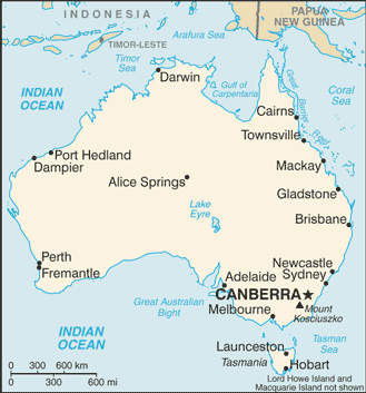
As-map.png (୩୨୯ × ୩୫୩ ପିକସେଲ, ଫାଇଲ ଆକାର: ୨୧ KB, ଏମ.ଆଇ.ଏମ.ଇର ପ୍ରକାର: image/png)
This is a file from the Wikimedia Commons. Information from its description page there is shown below. |

|
This map image could be re-created using vector graphics as an SVG file. This has several advantages; see Commons:Media for cleanup for more information. If an SVG form of this image is available, please upload it and afterwards replace this template with
{{vector version available|new image name}}.
It is recommended to name the SVG file “As-map.svg”—then the template Vector version available (or Vva) does not need the new image name parameter. |
ସାରକଥା
| ବିବରଣୀ |
Lëtzebuergesch: Kaart vun Australien. |
| ତାରିଖ | ୧୯ ଜୁଲାଇ ୨୦୦୭ |
| ମୂଳାଧାର |
CIA World Factbook |
| ଲେଖକ | United States Central Intelligence Agency |
| ଅନ୍ୟ ସଂସ୍କରଣ |
|
.png)
ସତ୍ଵ
This image is in the public domain because it contains materials that originally came from the United States Central Intelligence Agency's World Factbook.
|
 |
ଫାଇଲ ଇତିହାସ
ଏହା ଫାଇଲଟି ସେତେବେଳେ ଯେମିତି ଦିଶୁଥିଲା ତାହା ଦେଖିବା ପାଇଁ ତାରିଖ/ବେଳା ଉପରେ କ୍ଲିକ କରନ୍ତୁ
| ତାରିଖ/ବେଳ | ନଖ ଦେଖଣା | ଆକାର | ବ୍ୟବହାରକାରୀ | ମତାମତ | |
|---|---|---|---|---|---|
| ଏବେକାର | ୨୨:୧୮, ୨୮ ଜାନୁଆରୀ ୨୦୦୯ | | ୩୨୯ × ୩୫୩ (୨୧ KB) | DaniDF1995 | Reverted to version as of 16:48, 28 January 2009 |
| ୨୨:୧୮, ୨୮ ଜାନୁଆରୀ ୨୦୦୯ |  | ୩୨୯ × ୩୮୬ (୨୦ KB) | DaniDF1995 | Some fix | |
| ୨୨:୧୮, ୨୮ ଜାନୁଆରୀ ୨୦୦୯ |  | ୩୨୯ × ୩୫୩ (୨୧ KB) | DaniDF1995 | Reverted to version as of 16:46, 28 January 2009 | |
| ୨୨:୧୭, ୨୮ ଜାନୁଆରୀ ୨୦୦୯ |  | ୩୨୯ × ୩୮୬ (୨୦ KB) | DaniDF1995 | Some fix | |
| ୨୨:୧୬, ୨୮ ଜାନୁଆରୀ ୨୦୦୯ |  | ୩୨୯ × ୩୫୩ (୨୧ KB) | DaniDF1995 | Reverted to version as of 09:57, 25 July 2007 | |
| ୨୨:୧୫, ୨୮ ଜାନୁଆରୀ ୨୦୦୯ |  | ୩୨୯ × ୩୮୬ (୨୦ KB) | DaniDF1995 | Some fix | |
| ୧୫:୨୭, ୨୫ ଜୁଲାଇ ୨୦୦୭ |  | ୩୨୯ × ୩୫୩ (୨୧ KB) | Hoshie | Updated map of Australia from the CIA World Factbook, 19 July 07 rev. Src: https://www.cia.gov/library/publications/the-world-factbook/maps/as-map.gif | |
| ୨୦:୩୭, ୨୬ ଫେବୃଆରୀ ୨୦୦୫ |  | ୩୨୮ × ୩୫୨ (୧୩ KB) | Alfio | CIA map of Australia |
ଫାଇଲ ବ୍ୟବହାର
ଏହି ସବୁ4 ପୃଷ୍ଠାସବୁ ଏହି ଫାଇଲଟିକୁ ଯୋଡ଼ିଥାନ୍ତି:
ଜଗତ ଫାଇଲ ବ୍ୟବହାର
ତଳଲିଖିତ ଉଇକିସବୁ ଏହି ଫାଇଲଟିକୁ ବ୍ୟବହାର କରିଥାନ୍ତି:
- ab.wikipedia.orgରେ ବ୍ୟବହାର
- af.wikipedia.orgରେ ବ୍ୟବହାର
- arz.wikipedia.orgରେ ବ୍ୟବହାର
- azb.wikipedia.orgରେ ବ୍ୟବହାର
- bbc.wikipedia.orgରେ ବ୍ୟବହାର
- bg.wikipedia.orgରେ ବ୍ୟବହାର
- bh.wikipedia.orgରେ ବ୍ୟବହାର
- bjn.wikipedia.orgରେ ବ୍ୟବହାର
- bn.wikipedia.orgରେ ବ୍ୟବହାର
- ca.wikipedia.orgରେ ବ୍ୟବହାର
- ckb.wikipedia.orgରେ ବ୍ୟବହାର
- cs.wikipedia.orgରେ ବ୍ୟବହାର
- cv.wikipedia.orgରେ ବ୍ୟବହାର
- da.wikipedia.orgରେ ବ୍ୟବହାର
- de.wikinews.orgରେ ବ୍ୟବହାର
- dsb.wikipedia.orgରେ ବ୍ୟବହାର
- dty.wikipedia.orgରେ ବ୍ୟବହାର
- en.wikipedia.orgରେ ବ୍ୟବହାର
- List of cities in Australia
- Wikipedia talk:WikiProject Countries/Proposal 1
- Trans Australia Airlines Flight 538
- User:Peursem
- Outline of Australia
- Wikipedia:Recent additions/2004/April
- Module:Location map/data/Australia/doc
- User talk:Nil Einne
- Module:Location map/data/Australia
- North Australian Basin
- en.wikibooks.orgରେ ବ୍ୟବହାର
- en.wikinews.orgରେ ବ୍ୟବହାର
- eo.wikipedia.orgରେ ବ୍ୟବହାର
- es.wikipedia.orgରେ ବ୍ୟବହାର
- fa.wikipedia.orgରେ ବ୍ୟବହାର
- fi.wikipedia.orgରେ ବ୍ୟବହାର
- fi.wikinews.orgରେ ବ୍ୟବହାର
- fo.wikipedia.orgରେ ବ୍ୟବହାର
- fr.wikipedia.orgରେ ବ୍ୟବହାର
ଏହି ଫାଇଲଟିର ଅଧିକ ବିଶ୍ୱବ୍ୟାପୀ ବ୍ୟବହାର ଦେଖନ୍ତୁ ।