ଫାଇଲ:Spg05 plan.jpg
ଏହି ଦେଖଣାର ଆକାର: ୪୫୩ × ୬୦୦ ପିକ୍ସେଲ । ବାକି ରେଜୋଲୁସନ: ୧୮୧ × ୨୪୦ ପିକ୍ସେଲ | ୩୬୨ × ୪୮୦ ପିକ୍ସେଲ | ୫୮୦ × ୭୬୮ ପିକ୍ସେଲ | ୭୭୩ × ୧,୦୨୪ ପିକ୍ସେଲ | ୧,୪୪୨ × ୧,୯୦୯ ପିକ୍ସେଲ.
ମୂଳ ଫାଇଲ (୧,୪୪୨ × ୧,୯୦୯ ପିକସେଲ, ଫାଇଲ ଆକାର: ୩୮୬ KB, ଏମ.ଆଇ.ଏମ.ଇର ପ୍ରକାର: image/jpeg)
This is a file from the Wikimedia Commons. Information from its description page there is shown below. |
ସାରକଥା
| ବିବରଣୀ |
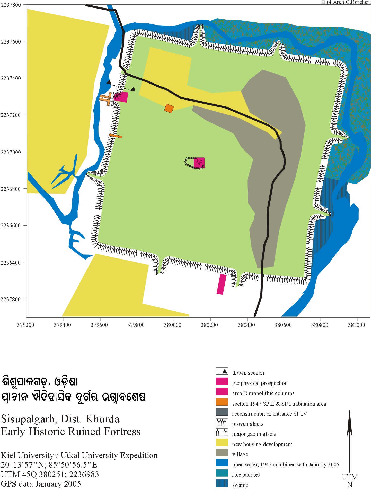
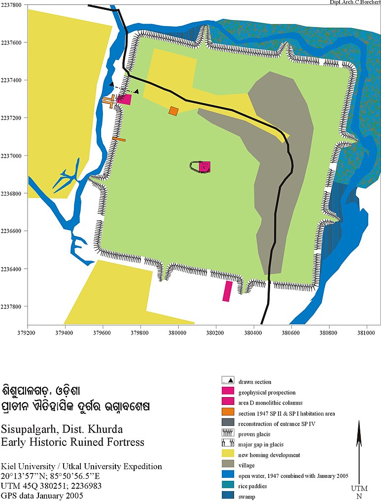
ଓଡ଼ିଆ: ଶିଶୁପାଳଗଡ଼, ପୁରୁଣା ଭୁବନେଶ୍ଵରର ଅନତିଦୂରରେ ଦୟାନଦୀ ନିକଟରେ ଏହି ପୁରୁଣା ନଗରର ଭଗ୍ନାବଶେଷ ଏଠାରେ ଦେଖିବାକୁ ମିଳିଥାଏ । English: Detailed map of Sisupalagada.
The remains of the ancient city Sisupalgarh has been discovered near Bhubaneswar,capital of an eastern state of Orissa in India.Archaeologists claim the city to be at least 2,500 years old. |
| ତାରିଖ | ୫ ଡିସେମ୍ବର ୨୦୦୭ (original upload date) |
| ମୂଳାଧାର | Transferred from en.wikipedia. |
| ଲେଖକ | Pyule at en.wikipedia |
| Camera location | | View this and other nearby images on: OpenStreetMap |
|---|
ସତ୍ଵ
| ଏହି କାମଟି ପବ୍ଲିକ ଡୋମେନ ରେ ଏହାର ଗଢ଼ାଳିPyule at ଇଂରାଜୀ ଉଇକିପିଡ଼ିଆଙ୍କ ଦେଇ ପ୍ରକାଶିତ ହେଲା, ଏହା ଜଗତସାରା ଲାଗୁ । କେତେକ ଦେଶରେ ଏହା ନ୍ୟାୟମତେ ଅନୁମୋଦିତ ହୋଇନପାରେ, ଯଦି ସେମିତି ହୁଏ: Pyule ଯେ ପର୍ଯ୍ୟନ୍ତ ଆଇନରେ କିଛି ସର୍ତ୍ତ ଦରକାର ନ ପଡ଼େ ସେ ପର୍ଯ୍ୟନ୍ତ ସଭିଙ୍କୁ କୌଣସି ବି ଉଦ୍ଦେଶ୍ୟରେ ଏହ କାମଟିକୁ ନିସର୍ତ୍ତ ବ୍ୟବହାର କରିବାକୁ ଅନୁମତି ଦେଉଛନ୍ତି । |
ମୂଲ ଅପଲୋଡ଼ ଫାଇଲ
The original description page was here. All following user names refer to en.wikipedia.
- 2007-12-05 22:32 Pyule 1442×1909× (394786 bytes) Sisupalgarh plan
ଫାଇଲ ଇତିହାସ
ଏହା ଫାଇଲଟି ସେତେବେଳେ ଯେମିତି ଦିଶୁଥିଲା ତାହା ଦେଖିବା ପାଇଁ ତାରିଖ/ବେଳା ଉପରେ କ୍ଲିକ କରନ୍ତୁ
| ତାରିଖ/ବେଳ | ନଖ ଦେଖଣା | ଆକାର | ବ୍ୟବହାରକାରୀ | ମତାମତ | |
|---|---|---|---|---|---|
| ଏବେକାର | ୨୩:୦୦, ୨୭ ଅକ୍ଟୋବର ୨୦୧୧ | | ୧,୪୪୨ × ୧,୯୦୯ (୩୮୬ KB) | Psubhashish |
ଫାଇଲ ବ୍ୟବହାର
ଏହି ସବୁପୃଷ୍ଠା ଏହି ଫାଇଲଟିକୁ ଯୋଡ଼ିଥାନ୍ତି:
ଜଗତ ଫାଇଲ ବ୍ୟବହାର
ତଳଲିଖିତ ଉଇକିସବୁ ଏହି ଫାଇଲଟିକୁ ବ୍ୟବହାର କରିଥାନ୍ତି:
- bn.wikipedia.orgରେ ବ୍ୟବହାର
- en.wikipedia.orgରେ ବ୍ୟବହାର
- fr.wikipedia.orgରେ ବ୍ୟବହାର
- pt.wikipedia.orgରେ ବ୍ୟବହାର
- si.wikipedia.orgରେ ବ୍ୟବହାର