ଫାଇଲ:Red Fort drawing.svg

Size of this PNG preview of this SVG file: ୩୦୧ × ୫୯୯ ପିକ୍ସେଲ. ବାକି ରେଜୋଲୁସନ: ୧୨୦ × ୨୪୦ ପିକ୍ସେଲ | ୨୪୧ × ୪୮୦ ପିକ୍ସେଲ | ୩୮୬ × ୭୬୮ ପିକ୍ସେଲ | ୫୧୫ × ୧,୦୨୪ ପିକ୍ସେଲ | ୧,୦୨୯ × ୨,୦୪୮ ପିକ୍ସେଲ | ୧,୦୦୦ × ୧,୯୮୯ ପିକ୍ସେଲ.
ମୂଳ ଫାଇଲ (SVG ଫାଇଲ, ସାଧାରଣ ମାପ ୧,୦୦୦ × ୧,୯୮୯ ପିକ୍ସେଲ, ଫାଇଲ ଆକାର: ୩୨୧ KB)
This is a file from the Wikimedia Commons. Information from its description page there is shown below. |
ସାରକଥା
| ବିବରଣୀ |
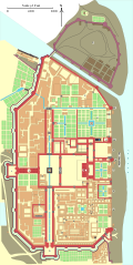
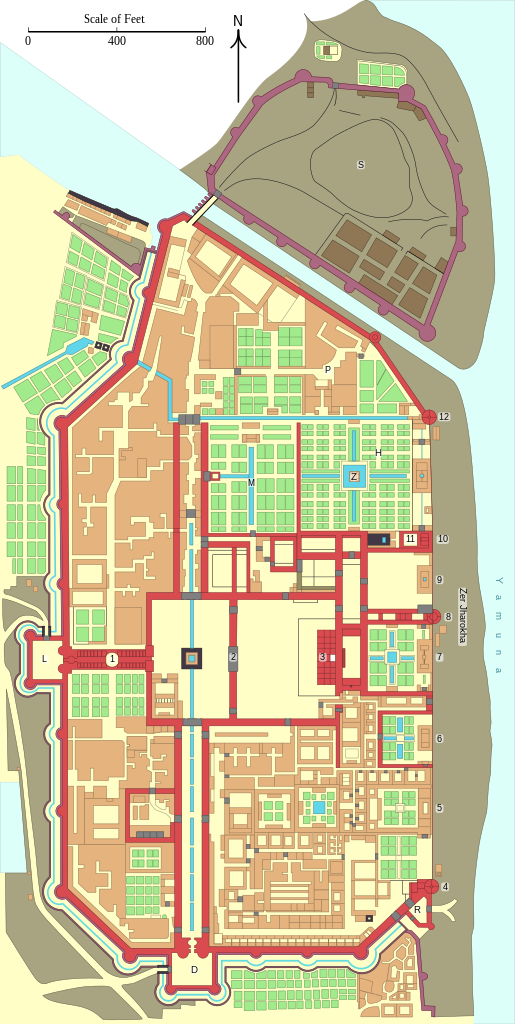
English: Floor plan of the Red Fort in Delhi before 1857.
|
|||||||||||||||||||||||
| ତାରିଖ | ||||||||||||||||||||||||
| ମୂଳାଧାର |
ଆପଣା କାମ |
|||||||||||||||||||||||
| ଲେଖକ | Goran tek-en | |||||||||||||||||||||||
| ଅନୁମତି (ଏହି ଫାଇଲକୁ ପୁଣି ବ୍ୟବହାର କରିବେ) |
This file is licensed under the Creative Commons Attribution-Share Alike 4.0 International license. ଶ୍ରେୟ: Goran tek-en
|
|||||||||||||||||||||||
| ଅନ୍ୟ ସଂସ୍କରଣ |
|
|||||||||||||||||||||||
| SVG genesis | This W3C-invalid vector image was created with Inkscape, or with something else.
|
|||||||||||||||||||||||


| Object location | | View this and other nearby images on: OpenStreetMap |
|---|


| Annotations | This image is annotated: View the annotations at Commons |

|
This image has been assessed under the valued image criteria and is considered the most valued image on Commons within the scope: Floor plan of the Red Fort in Delhi before 1857.. You can see its nomination here. |
ଫାଇଲ ଇତିହାସ
ଏହା ଫାଇଲଟି ସେତେବେଳେ ଯେମିତି ଦିଶୁଥିଲା ତାହା ଦେଖିବା ପାଇଁ ତାରିଖ/ବେଳା ଉପରେ କ୍ଲିକ କରନ୍ତୁ
| ତାରିଖ/ବେଳ | ନଖ ଦେଖଣା | ଆକାର | ବ୍ୟବହାରକାରୀ | ମତାମତ | |
|---|---|---|---|---|---|
| ଏବେକାର | ୦୦:୨୧, ୧୯ ନଭେମ୍ବର ୨୦୨୧ | | ୧,୦୦୦ × ୧,୯୮୯ (୩୨୧ KB) | Goran tek-en | ppi to 96, optimized |
| ୨୦:୦୪, ୩ ମାର୍ଚ୍ଚ ୨୦୧୪ |  | ୧,୦୦୦ × ୧,୯୮୯ (୬୭୬ KB) | Goran tek-en | Minor changes | |
| ୨୨:୨୪, ୨୧ ଫେବୃଆରୀ ୨୦୧୪ |  | ୧,୦୦୦ × ୧,୯୮୯ (୬୭୭ KB) | Goran tek-en | Larger nominally size | |
| ୧୯:୪୫, ୨୧ ଫେବୃଆରୀ ୨୦୧୪ |  | ୪୯୭ × ୯୮୯ (୬୬୫ KB) | Goran tek-en | User created page with UploadWizard |
ଫାଇଲ ବ୍ୟବହାର
ଏହି ସବୁପୃଷ୍ଠା ଏହି ଫାଇଲଟିକୁ ଯୋଡ଼ିଥାନ୍ତି:
ଜଗତ ଫାଇଲ ବ୍ୟବହାର
ତଳଲିଖିତ ଉଇକିସବୁ ଏହି ଫାଇଲଟିକୁ ବ୍ୟବହାର କରିଥାନ୍ତି:
- de.wikipedia.orgରେ ବ୍ୟବହାର
- no.wikipedia.orgରେ ବ୍ୟବହାର