ଫାଇଲ:Punjab district map.png

ଏହି ଦେଖଣାର ଆକାର: ୫୪୦ × ୬୦୦ ପିକ୍ସେଲ । ବାକି ରେଜୋଲୁସନ: ୨୧୬ × ୨୪୦ ପିକ୍ସେଲ | ୪୩୨ × ୪୮୦ ପିକ୍ସେଲ | ୬୯୧ × ୭୬୮ ପିକ୍ସେଲ | ୯୨୨ × ୧,୦୨୪ ପିକ୍ସେଲ | ୨,୪୬୭ × ୨,୭୪୧ ପିକ୍ସେଲ.
ମୂଳ ଫାଇଲ (୨,୪୬୭ × ୨,୭୪୧ ପିକସେଲ, ଫାଇଲ ଆକାର: ୬୩୫ KB, ଏମ.ଆଇ.ଏମ.ଇର ପ୍ରକାର: image/png)
This is a file from the Wikimedia Commons. Information from its description page there is shown below. |

|
This locator map image could be re-created using vector graphics as an SVG file. This has several advantages; see Commons:Media for cleanup for more information. If an SVG form of this image is available, please upload it and afterwards replace this template with
{{vector version available|new image name}}.
It is recommended to name the SVG file “Punjab district map.svg”—then the template Vector version available (or Vva) does not need the new image name parameter. |
ସାରକଥା
| ବିବରଣୀ |
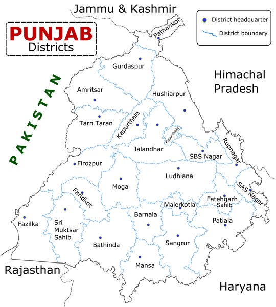
English: State of Punjab (Indian Punjab) with districts marked along with district Headquarters. |
| ତାରିଖ | |
| ମୂଳାଧାର | Self made using Inkscape. Source map referred from Punjab govt. site. |
| ଲେଖକ | Wikigringo |
ସତ୍ଵ
ମୁଁ, ଏହି କାମର ସତ୍ୱାଧିକାରୀ, ଏଠାରେ ତଳଲିଖିତ ଲାଇସେନ୍ସ ଅଧୀନରେ ଏହାକୁ ପ୍ରକାଶ କଲି:

|
ମାଗଣା ସଫ୍ଟବେର ଫାଉଣ୍ଡେସନ ଦେଇ ପ୍ରକାଶିତ କୌଣସି ବଦଳାଇ ନହେବା ଭଳି ଧାରା, ଆଗ ବା ପଛ ପଟ ମଲାଟ ବିନା GNU ଖୋଲା ଦଲିଲକାରଣ ଲାଇସେନ୍ସ ୧.୨ ତମ ସଙ୍କଳନ ବା ଆଉ କୌଣସି ସର୍ତ୍ତାବଳି ଅନୁସାରେ ଏହି ଦଲିଲର ନକଲ, ବଣ୍ଟନ ତଥା/କିମ୍ବା ବଦଳାଇବା ନିମନ୍ତେ ଅନୁମତି ଦିଆଗଲା । GNU ମାଗଣା ଦଲିଲକରଣ ଲାଇସେନ୍ସ ନାମକ ବିଭାଗରେ ଲାଇସେନ୍ସର ନକଲ ଦିଆଯାଇଅଛି । |
This file is licensed under the Creative Commons Attribution-Share Alike 4.0 International, 3.0 Unported, 2.5 Generic, 2.0 Generic and 1.0 Generic license.
- ଆପଣ ଆରାମରେ:
- ବାଣ୍ଟିପାରିବେ – କାମଟିକୁ ନକଲ କରିପାରିବେ, ବାଣ୍ଟିପାରିବେ ଓ ପ୍ରସାରଣ କରିପାରିବେ
- ମିଶାଇପାରିବେ – କାମଟି ଅଭିଯୋଜନ କରିପାରିବେ
- ତଳଲିଖିତ ସର୍ତ୍ତାବଳୀ ଅଧୀନରେ:
- ଶ୍ରେୟ – ଆପଣ ମନେ କରି ଏହି କାମର ଆବଶ୍ୟକୀୟ ଶ୍ରେୟ ମୂଳ ଗଢ଼ାଳି ବା ସ୍ୱତ୍ୱାଧୀକାରୀଙ୍କୁ ଦେବେ ଏବଂ ଦେଲାବେଳେ ଲାଇସେନ୍ସର ଲିଙ୍କ ଦେଇ କି କି ବଦଳ କଲେ ଉଲ୍ଲେଖ କରିବେ । ଏହା ଉପଯୁକ୍ତ ଢଙ୍ଗରେ କରିବେ କିନ୍ତୁ ଲାଇସେନ୍ସ ଦେଉଥିବା ବ୍ୟକ୍ତି ଆପଣଙ୍କ ପ୍ରଚାର କଲା ଭଳି କିଛି ଲେଖିବେ ନାହିଁ ।
- ସେଆର ଏଲାଇକ – ଯଦି ଆପଣ ଏହି କାମଟିକୁ ବଦଳାଇବେ, ରୂପାନ୍ତରଣ କରିବେ ବା ଏହାକୁ ନେଇ କିଛି ଗଢ଼ିବେ ତେବେ ଆପଣ ଏହାକୁ ଏକା ବା ଅଲଗା ଲାଇସେନ୍ସ ଭିତରେ ରଖିପାରିବେ ।
ଆପଣ ନିଜ ପସନ୍ଦର ଲାଇସେନ୍ସ ବାଛିପାରିବେ ।
ଫାଇଲ ଇତିହାସ
ଏହା ଫାଇଲଟି ସେତେବେଳେ ଯେମିତି ଦିଶୁଥିଲା ତାହା ଦେଖିବା ପାଇଁ ତାରିଖ/ବେଳା ଉପରେ କ୍ଲିକ କରନ୍ତୁ
| ତାରିଖ/ବେଳ | ନଖ ଦେଖଣା | ଆକାର | ବ୍ୟବହାରକାରୀ | ମତାମତ | |
|---|---|---|---|---|---|
| ଏବେକାର | ୧୪:୫୫, ୧୦ ଜାନୁଆରୀ ୨୦୨୩ | | ୨,୪୬୭ × ୨,୭୪୧ (୬୩୫ KB) | Saad Ali Khan Pakistan | updated district MalerKotla on map |
| ୧୦:୧୫, ୭ ଜୁଲାଇ ୨୦୨୦ |  | ୨,୪୬୭ × ୨,୭୪୧ (୮୬୭ KB) | Kaushal Bishnoi | New Update version of Punjab District Map with 22 District. | |
| ୨୦:୧୧, ୫ ଅକ୍ଟୋବର ୨୦୧୩ |  | ୧,୦୯୪ × ୮୪୮ (୧୨୭ KB) | Ras67 | cropped and optimized | |
| ୧୪:୧୦, ୨୮ ଅପ୍ରେଲ ୨୦୦୮ |  | ୧,୨୧୧ × ୮୭୪ (୧୮୭ KB) | Wikigringo | Uploading a better color version of the file with bigger font size. | |
| ୨୧:୩୧, ୨୬ ଅପ୍ରେଲ ୨୦୦୮ |  | ୧,୨୬୯ × ୯୦୭ (୧୬୭ KB) | Wikigringo | {{Information |Description=State of Punjab, India with districts marked along with district HQ. |Source=Self made using Inkscape. Source map referred from Punjab govt. site. |Date=04/26/2008 |Author=Wikigringo |Permission= |other_versions= }} |
ଫାଇଲ ବ୍ୟବହାର
ଏହି ଫାଇଲ ସହିତ ଯୋଡ଼ା ଗୋଟିଏ ବି ପୃଷ୍ଠା ନାହିଁ ।
ଜଗତ ଫାଇଲ ବ୍ୟବହାର
ତଳଲିଖିତ ଉଇକିସବୁ ଏହି ଫାଇଲଟିକୁ ବ୍ୟବହାର କରିଥାନ୍ତି:
- ar.wikipedia.orgରେ ବ୍ୟବହାର
- azb.wikipedia.orgରେ ବ୍ୟବହାର
- bh.wikipedia.orgରେ ବ୍ୟବହାର
- bn.wikipedia.orgରେ ବ୍ୟବହାର
- ca.wikipedia.orgରେ ବ୍ୟବହାର
- ceb.wikipedia.orgରେ ବ୍ୟବହାର
- en.wikipedia.orgରେ ବ୍ୟବହାର
- es.wikipedia.orgରେ ବ୍ୟବହାର
- eu.wikipedia.orgରେ ବ୍ୟବହାର
- fa.wikipedia.orgରେ ବ୍ୟବହାର
- fi.wikipedia.orgରେ ବ୍ୟବହାର
- fr.wikipedia.orgରେ ବ୍ୟବହାର
- Pendjab (Inde)
- District de Barnala
- District de Faridkot
- District de Fatehgarh Sahib
- District de Fazilka
- District de Firozpur
- District de Gurdaspur
- District de Hoshiarpur
- District de Jalandhar
- District de Kapurthala
- District de Ludhiana
- District de Mansa (Penjab)
- District de Moga
- District de Mohali
- District de Muktsar
ଏହି ଫାଇଲଟିର ଅଧିକ ବିଶ୍ୱବ୍ୟାପୀ ବ୍ୟବହାର ଦେଖନ୍ତୁ ।