ଫାଇଲ:Nagaland locator map.svg

ମୂଳ ଫାଇଲ (SVG ଫାଇଲ, ସାଧାରଣ ମାପ ୨,୩୯୩ × ୧,୯୫୬ ପିକ୍ସେଲ, ଫାଇଲ ଆକାର: ୨୭୭ KB)
This is a file from the Wikimedia Commons. Information from its description page there is shown below. |
| ଶିରୋନାମ |
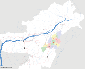
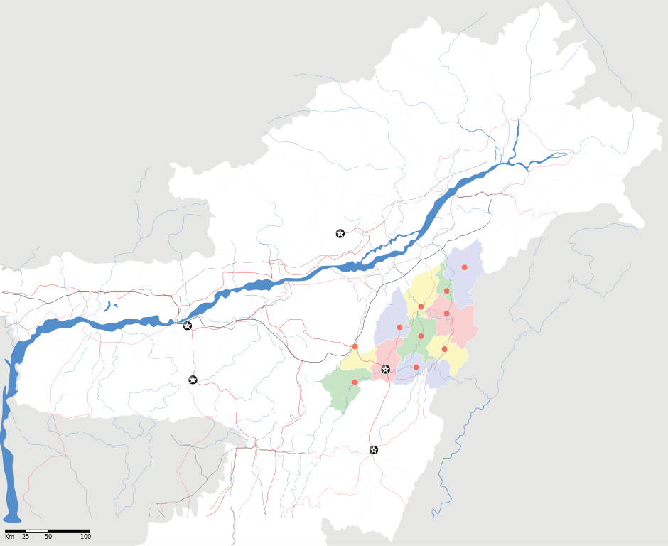
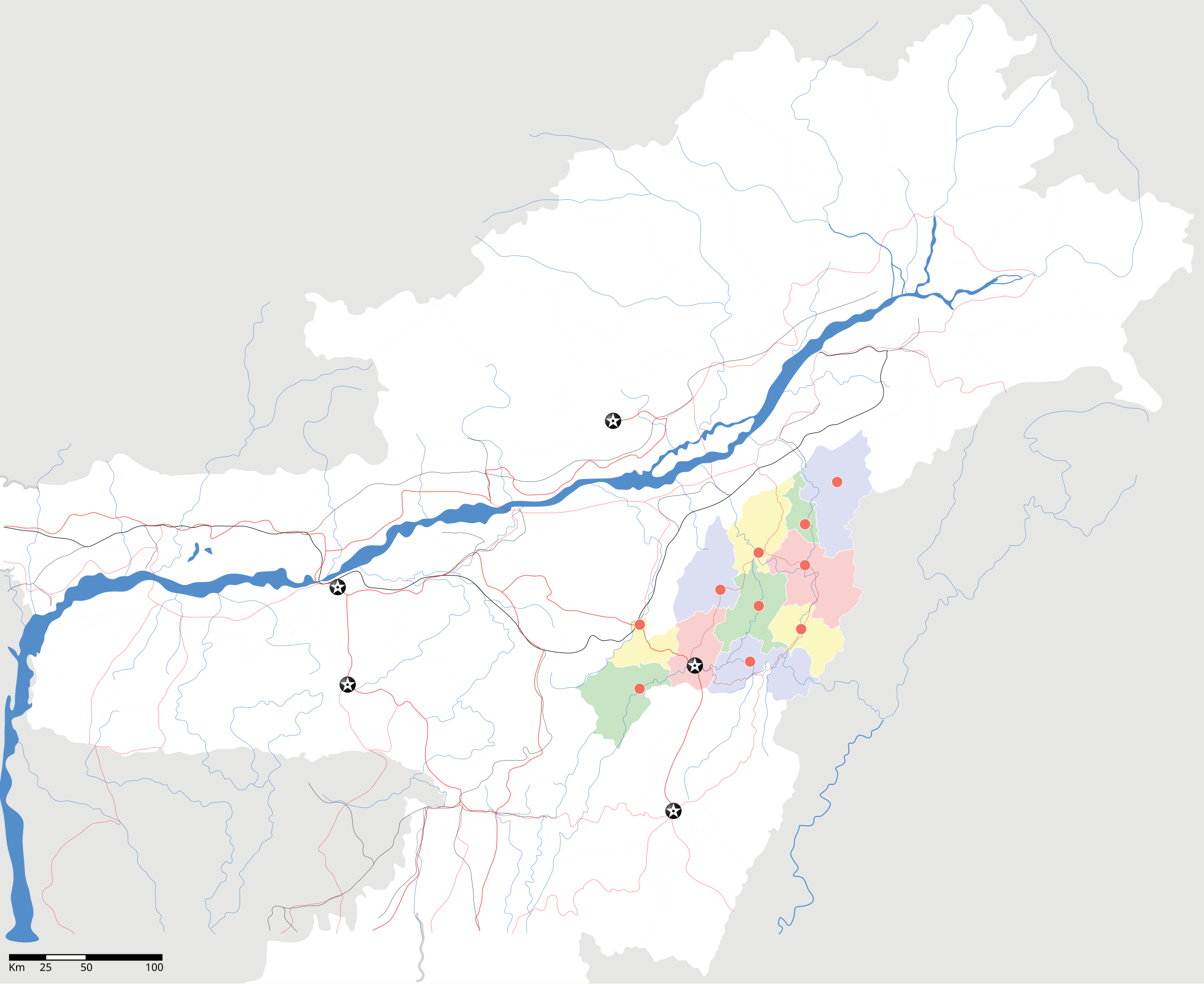
Nagaland locator Map |
| Description |
Map of w:Nagaland with road and rail lines. Equirectangular projection. Geographic limits of the map: top=29.49, bottom=23.74, left=89.61, right=97.52. |
| ତାରିଖ | |
| ମୂଳାଧାର |
ଆପଣା କାମ |
| Creator | |
| ଅନୁମତି (ଏହି ଫାଇଲକୁ ପୁଣି ବ୍ୟବହାର କରିବେ) |
ମୁଁ, ଏହି କାମର ସତ୍ଵାଧିକାରୀ, ଏଠାରେ ତଳଲିଖିତ ଲାଇସେନ୍ସ ଅଧୀନରେ ଏହାକୁ ପ୍ରକାଶ କଲି: ଏହି ଫାଇଲଟି କ୍ରିଏଟିଭ କମନ୍ସ ଅଧୀନରେ ଆଟ୍ରିବୁସନ ସେଆର-ଏଲାଇକ ୩.୦ ଅନପୋର୍ଟେଡ଼ ଲାଇସେନ୍ସରେ ପଞ୍ଜିକରଣ କରାଯାଇଅଛି ।
|
| Geotemporal data | |
| Date depicted | second half of 20 century ଓ 21 century |
| Georeferencing | If inappropriate please set warp_status = skip to hide. |
| Archival data | |
| ଟୀକା | Part of WikiProject India Maps |
ଫାଇଲ ଇତିହାସ
ଏହା ଫାଇଲଟି ସେତେବେଳେ ଯେମିତି ଦିଶୁଥିଲା ତାହା ଦେଖିବା ପାଇଁ ତାରିଖ/ବେଳା ଉପରେ କ୍ଲିକ କରନ୍ତୁ
| ତାରିଖ/ବେଳ | ନଖ ଦେଖଣା | ଆକାର | ବ୍ୟବହାରକାରୀ | ମତାମତ | |
|---|---|---|---|---|---|
| ଏବେକାର | ୧୭:୩୫, ୧୭ ଅପ୍ରେଲ ୨୦୦୭ | | ୨,୩୯୩ × ୧,୯୫୬ (୨୭୭ KB) | Planemad | not displaying, reupload |
| ୧୭:୩୦, ୧୭ ଅପ୍ରେଲ ୨୦୦୭ |  | ୨,୩୯୩ × ୧,୯୫୬ (୨୭୭ KB) | Planemad | not displaying, reupload | |
| ୧୭:୨୫, ୧୭ ଅପ୍ରେଲ ୨୦୦୭ |  | ୨,୩୯୩ × ୧,୯୫୬ (୨୭୭ KB) | Planemad | {{WikiProject_India_Maps |Title=Nagaland locator Map |Description=Map of w:Nagaland with road and rail lines |Source= [http://www.iitg.ernet.in/rcilts/assam_political.jpg IIT Guwahati - Assam Political map], [http://nagaland.nic.in/planning&coord/p |
ଫାଇଲ ବ୍ୟବହାର
ଏହି ସବୁପୃଷ୍ଠା ଏହି ଫାଇଲଟିକୁ ଯୋଡ଼ିଥାନ୍ତି:
ଜଗତ ଫାଇଲ ବ୍ୟବହାର
ତଳଲିଖିତ ଉଇକିସବୁ ଏହି ଫାଇଲଟିକୁ ବ୍ୟବହାର କରିଥାନ୍ତି:
- ar.wikipedia.orgରେ ବ୍ୟବହାର
- ast.wikipedia.orgରେ ବ୍ୟବହାର
- as.wikipedia.orgରେ ବ୍ୟବହାର
- ba.wikipedia.orgରେ ବ୍ୟବହାର
- bh.wikipedia.orgରେ ବ୍ୟବହାର
- bn.wikipedia.orgରେ ବ୍ୟବହାର
- ceb.wikipedia.orgରେ ବ୍ୟବହାର
- de.wikipedia.orgରେ ବ୍ୟବହାର
- en.wikipedia.orgରେ ବ୍ୟବହାର
- en.wikinews.orgରେ ବ୍ୟବହାର
- es.wikipedia.orgରେ ବ୍ୟବହାର
- fa.wikipedia.orgରେ ବ୍ୟବହାର
- hi.wikipedia.orgରେ ବ୍ୟବହାର
- ja.wikipedia.orgରେ ବ୍ୟବହାର
- kbd.wikipedia.orgରେ ବ୍ୟବହାର
- ml.wikipedia.orgରେ ବ୍ୟବହାର
- nl.wikipedia.orgରେ ବ୍ୟବହାର
- pam.wikipedia.orgରେ ବ୍ୟବହାର
- pa.wikipedia.orgରେ ବ୍ୟବହାର
- pnb.wikipedia.orgରେ ବ୍ୟବହାର
- sa.wikipedia.orgରେ ବ୍ୟବହାର
- sw.wikipedia.orgରେ ବ୍ୟବହାର
- ta.wikipedia.orgରେ ବ୍ୟବହାର
- tr.wikipedia.orgରେ ବ୍ୟବହାର
- vi.wikipedia.orgରେ ବ୍ୟବହାର
- war.wikipedia.orgରେ ବ୍ୟବହାର
- www.wikidata.orgରେ ବ୍ୟବହାର
- yo.wikipedia.orgରେ ବ୍ୟବହାର
- zh.wikipedia.orgରେ ବ୍ୟବହାର