ଫାଇଲ:Map of current Interstates.svg

Size of this PNG preview of this SVG file: ୬୮୯ × ୪୩୨ ପିକ୍ସେଲ. ବାକି ରେଜୋଲୁସନ: ୩୨୦ × ୨୦୧ ପିକ୍ସେଲ | ୬୪୦ × ୪୦୧ ପିକ୍ସେଲ | ୧,୦୨୪ × ୬୪୨ ପିକ୍ସେଲ | ୧,୨୮୦ × ୮୦୩ ପିକ୍ସେଲ | ୨,୫୬୦ × ୧,୬୦୫ ପିକ୍ସେଲ.
ମୂଳ ଫାଇଲ (SVG ଫାଇଲ, ସାଧାରଣ ମାପ ୬୮୯ × ୪୩୨ ପିକ୍ସେଲ, ଫାଇଲ ଆକାର: ୫୧୮ KB)
This is a file from the Wikimedia Commons. Information from its description page there is shown below. |

|
This file requires updating because: Multiple Interstates and future Interstate are Missing In doing so, you could add a timestamp to the file.
|
ସାରକଥା
| ବିବରଣୀ |
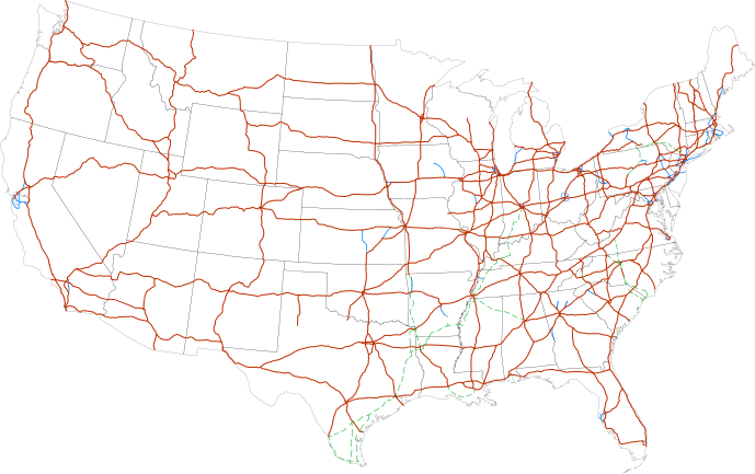
Labels:
One or Two-digit interstates (dark orange line)
Selected three-digit interstates (blue line)
Selected planned interstates (green dashed line) |
| ତାରିଖ | |
| ମୂଳାଧାର | National Atlas |
| ଲେଖକ | SPUI |
ସତ୍ଵ
| ଏହି କାମଟି ପବ୍ଲିକ ଡୋମେନ ରେ ଏହାର ଗଢ଼ାଳିSPUIଙ୍କ ଦେଇ ପ୍ରକାଶିତ ହେଲା, ଏହା ଜଗତସାରା ଲାଗୁ । କେତେକ ଦେଶରେ ଏହା ନ୍ୟାୟମତେ ଅନୁମୋଦିତ ହୋଇନପାରେ, ଯଦି ସେମିତି ହୁଏ: |
| Annotations | This image is annotated: View the annotations at Commons |
ଫାଇଲ ଇତିହାସ
ଏହା ଫାଇଲଟି ସେତେବେଳେ ଯେମିତି ଦିଶୁଥିଲା ତାହା ଦେଖିବା ପାଇଁ ତାରିଖ/ବେଳା ଉପରେ କ୍ଲିକ କରନ୍ତୁ
| ତାରିଖ/ବେଳ | ନଖ ଦେଖଣା | ଆକାର | ବ୍ୟବହାରକାରୀ | ମତାମତ | |
|---|---|---|---|---|---|
| ଏବେକାର | ୧୬:୪୯, ୧୩ ଫେବୃଆରୀ ୨୦୧୩ | | ୬୮୯ × ୪୩୨ (୫୧୮ KB) | Scott5114 | Add I-49 in Missouri |
| ୧୨:୦୯, ୧୧ ଜାନୁଆରୀ ୨୦୧୩ |  | ୬୮୯ × ୪୩୨ (୫୧୯ KB) | Agricolae | add I-376 rebranding north to I-80, planned I-99 from I-80 to I-86 | |
| ୧୨:୫୭, ୨ ଜୁଲାଇ ୨୦୧୧ |  | ୬୮୯ × ୪୩୨ (୪୮୫ KB) | Jkirkuslamont | Changed hues to improve legibility for the colour blind | |
| ୧୦:୦୬, ୧୦ ଜାନୁଆରୀ ୨୦୧୦ |  | ୬୮୯ × ୪୩୨ (୭୫୪ KB) | Techman224 | Made three-dight Interstates near Atlanta, Georgia blue | |
| ୦୩:୦୨, ୨୪ ଡିସେମ୍ବର ୨୦୦୯ |  | ୬୮୯ × ୪୩୨ (୭୫୪ KB) | Clorox | added I69 | |
| ୧୧:୪୨, ୨୯ ଫେବୃଆରୀ ୨୦୦୮ |  | ୬୮୯ × ୪୩୨ (୭୪୪ KB) | Alex43223 | Updated a couple highways | |
| ୦୮:୦୮, ୨୨ ଜୁନ ୨୦୦୭ |  | ୬୮୯ × ୪୩୨ (୬୮୭ KB) | Fran Rogers | Reverted to earlier revision | |
| ୦୮:୦୭, ୨୨ ଜୁନ ୨୦୦୭ |  | ୬୮୯ × ୪୩୨ (୬୮୭ KB) | Fran Rogers | {{spuimap}} Map of the present Interstate Highway System. Base map is [http://www.nationalatlas.gov/printable/images/pdf/reference/genref.pdf] (public domain US Federal Government). *Purple: two-digit *Blue: selected three-digit *Green: selected future ro | |
| ୨୧:୩୭, ୧୩ ଜୁଲାଇ ୨୦୦୬ |  | ୬୮୯ × ୪୩୨ (୬୮୭ KB) | SPUI~commonswiki | {{spuimap}} |
ଫାଇଲ ବ୍ୟବହାର
ଏହି ଫାଇଲ ସହିତ ଯୋଡ଼ା ଗୋଟିଏ ବି ପୃଷ୍ଠା ନାହିଁ ।
ଜଗତ ଫାଇଲ ବ୍ୟବହାର
ତଳଲିଖିତ ଉଇକିସବୁ ଏହି ଫାଇଲଟିକୁ ବ୍ୟବହାର କରିଥାନ୍ତି:
- an.wikipedia.orgରେ ବ୍ୟବହାର
- ar.wikipedia.orgରେ ବ୍ୟବହାର
- ast.wikipedia.orgରେ ବ୍ୟବହାର
- az.wikipedia.orgରେ ବ୍ୟବହାର
- bg.wikipedia.orgରେ ବ୍ୟବହାର
- bs.wikipedia.orgରେ ବ୍ୟବହାର
- ca.wikipedia.orgରେ ବ୍ୟବହାର
- da.wikipedia.orgରେ ବ୍ୟବହାର
- de.wikipedia.orgରେ ବ୍ୟବହାର
- en.wikipedia.orgରେ ବ୍ୟବହାର
- Economy of the United States
- Transportation in the United States
- List of gaps in Interstate Highways
- List of auxiliary Interstate Highways
- Controlled-access highway
- List of business routes of the Interstate Highway System
- User:Master son/US Roads
- User:Master son/US Roads/MTF
- Driving in the United States
- Trucking industry in the United States
- 1956 in the United States
- List of transport megaprojects
- User:Stephen100002/sandbox
- User:Vigneshdm1990/sandbox
- User:44Nifty/sandbox
- User:XanUltra
- Transportation policy of the United States
- Talk:United States/Archive 102
- Portal:Transport/Highway media
- Wikipedia talk:External links/Archive 42
- Wikipedia:Village pump (technical)/Archive 208
- en.wikibooks.orgରେ ବ୍ୟବହାର
- eo.wikipedia.orgରେ ବ୍ୟବହାର
- es.wikipedia.orgରେ ବ୍ୟବହାର
- et.wikipedia.orgରେ ବ୍ୟବହାର
- eu.wikipedia.orgରେ ବ୍ୟବହାର
- fa.wikipedia.orgରେ ବ୍ୟବହାର
- fi.wikipedia.orgରେ ବ୍ୟବହାର
ଏହି ଫାଇଲଟିର ଅଧିକ ବିଶ୍ୱବ୍ୟାପୀ ବ୍ୟବହାର ଦେଖନ୍ତୁ ।