ଫାଇଲ:Map of Izu Islands.png

ଏହି ଦେଖଣାର ଆକାର: ୫୩୫ × ୬୦୦ ପିକ୍ସେଲ । ବାକି ରେଜୋଲୁସନ: ୨୧୪ × ୨୪୦ ପିକ୍ସେଲ | ୪୨୮ × ୪୮୦ ପିକ୍ସେଲ | ୬୮୫ × ୭୬୮ ପିକ୍ସେଲ | ୧,୨୫୭ × ୧,୪୦୯ ପିକ୍ସେଲ.
ମୂଳ ଫାଇଲ (୧,୨୫୭ × ୧,୪୦୯ ପିକସେଲ, ଫାଇଲ ଆକାର: ୬୯୧ KB, ଏମ.ଆଇ.ଏମ.ଇର ପ୍ରକାର: image/png)
This is a file from the Wikimedia Commons. Information from its description page there is shown below. |
ସାରକଥା
| ବିବରଣୀ |
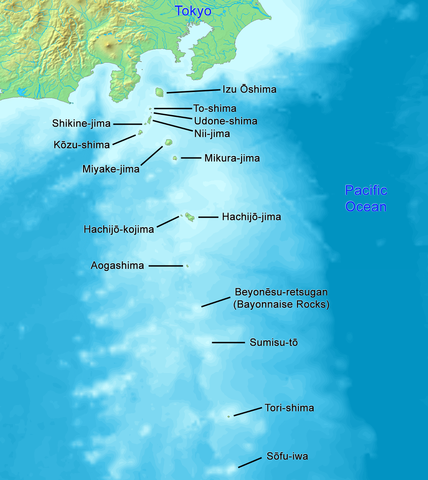
English: High quality map of the Izu Islands. This is the English (Romaji) version with Japanese names. Created with DEMIS World Map Server.
日本語: 日本語:高品質の地図、伊豆諸島。 |
| ତାରିଖ | |
| ମୂଳାଧାର | ଆପଣା କାମ |
| ଲେଖକ | Artanisen |
| ଅନ୍ୟ ସଂସ୍କରଣ |
|

ସତ୍ଵ
This image is in the public domain because it came from the site https://www.demis.nl/products/web-map-server/examples/ and was released by the copyright holder. Permission is granted to copy, distribute and/or modify this map since it is based on free of copyright images from: www.demis.nl. See also approval email on de.wp and its clarification.
|
| This work has been released into the public domain by its copyright holder, www.demis.nl. This applies worldwide. କେତେକ ଦେଶରେ ଏହା ନ୍ୟାୟମତେ ଅନୁମୋଦିତ ହୋଇନପାରେ, ଯଦି ସେମିତି ହୁଏ: www.demis.nl ଯେ ପର୍ଯ୍ୟନ୍ତ ଆଇନରେ କିଛି ସର୍ତ୍ତ ଦରକାର ନ ପଡ଼େ ସେ ପର୍ଯ୍ୟନ୍ତ ସଭିଙ୍କୁ କୌଣସି ବି ଉଦ୍ଦେଶ୍ୟରେ ଏହ କାମଟିକୁ ନିସର୍ତ୍ତ ବ୍ୟବହାର କରିବାକୁ ଅନୁମତି ଦେଉଛନ୍ତି ।
|

|
This map image could be re-created using vector graphics as an SVG file. This has several advantages; see Commons:Media for cleanup for more information. If an SVG form of this image is available, please upload it and afterwards replace this template with
{{vector version available|new image name}}.
It is recommended to name the SVG file “Map of Izu Islands.svg”—then the template Vector version available (or Vva) does not need the new image name parameter. |
ଫାଇଲ ଇତିହାସ
ଏହା ଫାଇଲଟି ସେତେବେଳେ ଯେମିତି ଦିଶୁଥିଲା ତାହା ଦେଖିବା ପାଇଁ ତାରିଖ/ବେଳା ଉପରେ କ୍ଲିକ କରନ୍ତୁ
| ତାରିଖ/ବେଳ | ନଖ ଦେଖଣା | ଆକାର | ବ୍ୟବହାରକାରୀ | ମତାମତ | |
|---|---|---|---|---|---|
| ଏବେକାର | ୦୬:୩୪, ୨୪ ଡିସେମ୍ବର ୨୦୨୧ | | ୧,୨୫୭ × ୧,୪୦୯ (୬୯୧ KB) | Artanisen | Reverted to version as of 10:15, 2 October 2019 (UTC) reverted to names in English only, because there is a separate Japanese map |
| ୧୨:୫୨, ୨୧ ଅକ୍ଟୋବର ୨୦୧୯ |  | ୧,୨୫୭ × ୧,୪୦୯ (୭୭୧ KB) | Artanisen | Added Japanese kanji of the island names and thinner black lines. | |
| ୧୫:୪୫, ୨ ଅକ୍ଟୋବର ୨୦୧୯ |  | ୧,୨୫୭ × ୧,୪୦୯ (୬୯୧ KB) | Artanisen | English: High quality map of the Izu Islands. Created with DEMIS World Map Server. 日本語:高品質の地図、伊豆諸島。 | |
| ୨୦:୨୧, ୫ ଅକ୍ଟୋବର ୨୦୦୬ |  | ୩୦୦ × ୪୦୦ (୩୨ KB) | Tdk~commonswiki | Map of Izu Islands. Created with DEMIS World Map Server.{{demis-pd}} |
ଫାଇଲ ବ୍ୟବହାର
ଏହି ସବୁପୃଷ୍ଠା ଏହି ଫାଇଲଟିକୁ ଯୋଡ଼ିଥାନ୍ତି:
ଜଗତ ଫାଇଲ ବ୍ୟବହାର
ତଳଲିଖିତ ଉଇକିସବୁ ଏହି ଫାଇଲଟିକୁ ବ୍ୟବହାର କରିଥାନ୍ତି:
- ar.wikipedia.orgରେ ବ୍ୟବହାର
- az.wikipedia.orgରେ ବ୍ୟବହାର
- bn.wikipedia.orgରେ ବ୍ୟବହାର
- ca.wikipedia.orgରେ ବ୍ୟବହାର
- ceb.wikipedia.orgରେ ବ୍ୟବହାର
- ckb.wikipedia.orgରେ ବ୍ୟବହାର
- cs.wikipedia.orgରେ ବ୍ୟବହାର
- da.wikipedia.orgରେ ବ୍ୟବହାର
- el.wikipedia.orgରେ ବ୍ୟବହାର
- en.wikipedia.orgରେ ବ୍ୟବହାର
- Geography of Japan
- Tokyo
- List of islands of Japan
- Devil's Sea
- Izu Islands
- Nii-jima
- Kōzu-shima
- Portal:Japan
- Shikine-jima
- Izu Ōshima
- Mikura-jima
- Lot's Wife (crag)
- Aogashima
- Tori-shima (Izu Islands)
- Hachijō-kojima
- Smith Island (Japan)
- Inamba-jima
- Udone-shima
- Ōnohara Islands
- Bayonnaise Rocks
- Hachijō language
- Jinai-tō
- List of governors of the Nanpō Islands
- Seven Islands of Izu
- en.wikibooks.orgରେ ବ୍ୟବହାର
- en.wikivoyage.orgରେ ବ୍ୟବହାର
- eo.wikipedia.orgରେ ବ୍ୟବହାର
- es.wikipedia.orgରେ ବ୍ୟବହାର
ଏହି ଫାଇଲଟିର ଅଧିକ ବିଶ୍ୱବ୍ୟାପୀ ବ୍ୟବହାର ଦେଖନ୍ତୁ ।