ଫାଇଲ:Maharashtra Divisions Eng.svg

Size of this PNG preview of this SVG file: ୭୫୯ × ୫୯୯ ପିକ୍ସେଲ. ବାକି ରେଜୋଲୁସନ: ୩୦୪ × ୨୪୦ ପିକ୍ସେଲ | ୬୦୮ × ୪୮୦ ପିକ୍ସେଲ | ୯୭୩ × ୭୬୮ ପିକ୍ସେଲ | ୧,୨୮୦ × ୧,୦୧୧ ପିକ୍ସେଲ | ୨,୫୬୦ × ୨,୦୨୨ ପିକ୍ସେଲ | ୩,୧୦୬ × ୨,୪୫୩ ପିକ୍ସେଲ.
ମୂଳ ଫାଇଲ (SVG ଫାଇଲ, ସାଧାରଣ ମାପ ୩,୧୦୬ × ୨,୪୫୩ ପିକ୍ସେଲ, ଫାଇଲ ଆକାର: ୨୮୯ KB)
This is a file from the Wikimedia Commons. Information from its description page there is shown below. |
ସାରକଥା
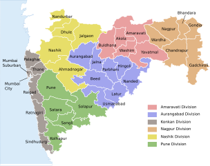
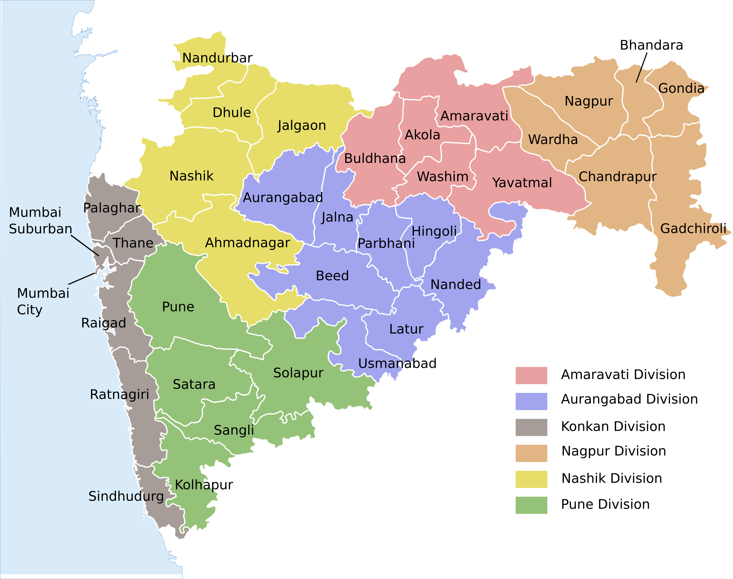
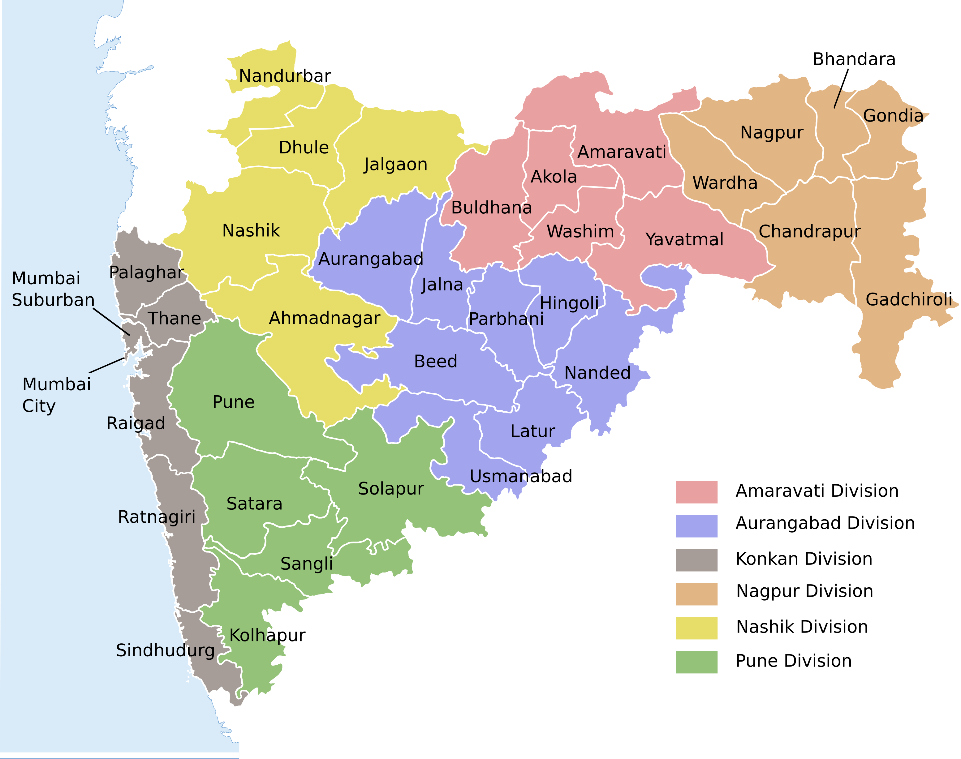
| ବିବରଣୀ | Locator map of the state of en:Maharashtra, India with district boundaries and Admin. divisions |
| ତାରିଖ | (UTC) |
| ମୂଳାଧାର | |
| ଲେଖକ |
|
| ଅନ୍ୟ ସଂସ୍କରଣ |
[]
|


| This is a retouched picture, which means that it has been digitally altered from its original version. Modifications: Added colour coding & divisions. The original can be viewed here: Maharashtra locator map.svg:
|
ଏହି ଫାଇଲଟି କ୍ରିଏଟିଭ କମନ୍ସ ଅଧୀନରେ ଆଟ୍ରିବୁସନ ସେଆର-ଏଲାଇକ ୩.୦ ଅନପୋର୍ଟେଡ଼ ଲାଇସେନ୍ସରେ ପଞ୍ଜିକରଣ କରାଯାଇଅଛି ।
- ଆପଣ ଆରାମରେ:
- ବାଣ୍ଟିପାରିବେ – କାମଟିକୁ ନକଲ କରିପାରିବେ, ବାଣ୍ଟିପାରିବେ ଓ ପ୍ରସାରଣ କରିପାରିବେ
- ମିଶାଇପାରିବେ – କାମଟି ଅଭିଯୋଜନ କରିପାରିବେ
- ତଳଲିଖିତ ସର୍ତ୍ତାବଳୀ ଅଧୀନରେ:
- ଶ୍ରେୟ – ଆପଣ ମନେ କରି ଏହି କାମର ଆବଶ୍ୟକୀୟ ଶ୍ରେୟ ମୂଳ ଗଢ଼ାଳି ବା ସ୍ୱତ୍ୱାଧୀକାରୀଙ୍କୁ ଦେବେ ଏବଂ ଦେଲାବେଳେ ଲାଇସେନ୍ସର ଲିଙ୍କ ଦେଇ କି କି ବଦଳ କଲେ ଉଲ୍ଲେଖ କରିବେ । ଏହା ଉପଯୁକ୍ତ ଢଙ୍ଗରେ କରିବେ କିନ୍ତୁ ଲାଇସେନ୍ସ ଦେଉଥିବା ବ୍ୟକ୍ତି ଆପଣଙ୍କ ପ୍ରଚାର କଲା ଭଳି କିଛି ଲେଖିବେ ନାହିଁ ।
- ସେଆର ଏଲାଇକ – ଯଦି ଆପଣ ଏହି କାମଟିକୁ ବଦଳାଇବେ, ରୂପାନ୍ତରଣ କରିବେ ବା ଏହାକୁ ନେଇ କିଛି ଗଢ଼ିବେ ତେବେ ଆପଣ ଏହାକୁ ଏକା ବା ଅଲଗା ଲାଇସେନ୍ସ ଭିତରେ ରଖିପାରିବେ ।
ମୂଲ ଅପଲୋଡ଼ ଫାଇଲ
This image is a derivative work of the following images:
- File:Maharashtra_locator_map.svg licensed with Cc-by-sa-3.0
- 2008-12-21T12:08:04Z Planemad 2789x2232 (365091 Bytes) {{Information |Description={{en|1=map}} |Source=Own work by uploader |Author=[[User:PlaneMad|PlaneMad]] |Date= |Permission= |other_versions= }}
Uploaded with derivativeFX
ଫାଇଲ ଇତିହାସ
ଏହା ଫାଇଲଟି ସେତେବେଳେ ଯେମିତି ଦିଶୁଥିଲା ତାହା ଦେଖିବା ପାଇଁ ତାରିଖ/ବେଳା ଉପରେ କ୍ଲିକ କରନ୍ତୁ
| ତାରିଖ/ବେଳ | ନଖ ଦେଖଣା | ଆକାର | ବ୍ୟବହାରକାରୀ | ମତାମତ | |
|---|---|---|---|---|---|
| ଏବେକାର | ୧୦:୨୪, ୧୫ ଅଗଷ୍ଟ ୨୦୨୦ | | ୩,୧୦୬ × ୨,୪୫୩ (୨୮୯ KB) | শরদিন্দু ভট্টাচার্য্য | File uploaded using svgtranslate tool (https://svgtranslate.toolforge.org/). Added translation for bn. |
| ୦୮:୧୦, ୩ ଅଗଷ୍ଟ ୨୦୨୦ |  | ୩,୧୦୬ × ୨,୪୫୩ (୨୬୨ KB) | C1MM | Added Palaghar | |
| ୨୧:୩୯, ୧୮ ଅଗଷ୍ଟ ୨୦୧୧ |  | ୩,୧୦୬ × ୨,୪୫୩ (୨୪୮ KB) | Kaajawa | {{Information |Description=Locator map of the state of en:Maharashtra, India with district boundaries and Admin. divisions |Source=*File:Maharashtra_locator_map.svg |Date=2011-08-18 16:06 (UTC) |Author=*[[:File:Maharashtra_locator_m |
ଫାଇଲ ବ୍ୟବହାର
ଏହି ସବୁପୃଷ୍ଠା ଏହି ଫାଇଲଟିକୁ ଯୋଡ଼ିଥାନ୍ତି:
ଜଗତ ଫାଇଲ ବ୍ୟବହାର
ତଳଲିଖିତ ଉଇକିସବୁ ଏହି ଫାଇଲଟିକୁ ବ୍ୟବହାର କରିଥାନ୍ତି:
- awa.wikipedia.orgରେ ବ୍ୟବହାର
- bh.wikipedia.orgରେ ବ୍ୟବହାର
- bn.wikipedia.orgରେ ବ୍ୟବହାର
- de.wikipedia.orgରେ ବ୍ୟବହାର
- dty.wikipedia.orgରେ ବ୍ୟବହାର
- en.wikipedia.orgରେ ବ୍ୟବହାର
- eu.wikipedia.orgରେ ବ୍ୟବହାର
- fi.wikipedia.orgରେ ବ୍ୟବହାର
- fr.wikipedia.orgରେ ବ୍ୟବହାର
- ha.wikipedia.orgରେ ବ୍ୟବହାର
- hi.wikipedia.orgରେ ବ୍ୟବହାର
- मुम्बई
- महाराष्ट्र
- पुणे
- नागपुर
- माथेरान
- मराठी भाषा
- विदर्भ
- अकोला
- नाशिक
- वर्धा
- अमरावती
- ठाणे
- जुन्नर तालुका
- जलगाँव
- अहमदनगर जिला
- अकोला जिला
- औरंगाबाद जिला, महाराष्ट्र
- अमरावती जिला
- बीड जिला
- भंडारा जिला
- बुलढाणा जिला
- चंद्रपुर जिला
- जालना जिला
- हिंगोली जिला
- गोंदिया जिला
- गढ़चिरौली जिला
- धुले जिला
- रायगढ़ जिला, महाराष्ट्र
- पुणे जिला
- परभणी जिला
- उस्मानाबाद जिला
- नाशिक जिला
- नंदुरबार जिला
ଏହି ଫାଇଲଟିର ଅଧିକ ବିଶ୍ୱବ୍ୟାପୀ ବ୍ୟବହାର ଦେଖନ୍ତୁ ।