ଫାଇଲ:Dromaius novaehollandiae map distribution 2.svg

Size of this PNG preview of this SVG file: ୭୩୬ × ୬୦୦ ପିକ୍ସେଲ. ବାକି ରେଜୋଲୁସନ: ୨୯୫ × ୨୪୦ ପିକ୍ସେଲ | ୫୮୯ × ୪୮୦ ପିକ୍ସେଲ | ୯୪୨ × ୭୬୮ ପିକ୍ସେଲ | ୧,୨୫୭ × ୧,୦୨୪ ପିକ୍ସେଲ | ୨,୫୧୩ × ୨,୦୪୮ ପିକ୍ସେଲ | ୧,୧୦୮ × ୯୦୩ ପିକ୍ସେଲ.
ମୂଳ ଫାଇଲ (SVG ଫାଇଲ, ସାଧାରଣ ମାପ ୧,୧୦୮ × ୯୦୩ ପିକ୍ସେଲ, ଫାଇଲ ଆକାର: ୧୧୪ KB)
This is a file from the Wikimedia Commons. Information from its description page there is shown below. |
ସାରକଥା
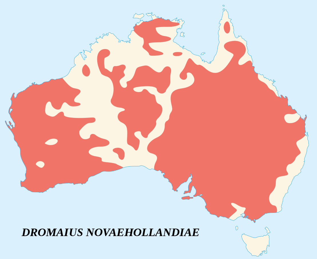
| ବିବରଣୀ |
English: Emu's recorded observations map (Dromaius Novaehollandiae).
Areas where emu has been recorded. Français : Carte d'observations de l'Émeu d'Australie (Dromaius Novaehollandiae).
Zones où des émeus ont été observés. |
||
| ତାରିଖ | |||
| ମୂଳାଧାର |
English:
Français : |
||
| ଲେଖକ | Sémhur (talk) | ||
| ଶ୍ରେୟ (required by the license) | © Sémhur / Wikimedia Commons / | ||
| SVG | W3C-validity not checked.
|
||
| Atelier graphique |

| Camera location | | View this and other nearby images on: OpenStreetMap |
|---|
ସତ୍ଵ
ମୁଁ, ଏହି କାମର ସତ୍ୱାଧିକାରୀ, ଏଠାରେ ତଳଲିଖିତ ଲାଇସେନ୍ସ ଅଧୀନରେ ଏହାକୁ ପ୍ରକାଶ କଲି:
| ସତ୍ଵହିନ: ଏହି କଳା କାମଟି ମୁକ୍ତ ଅଟେ; ଖୋଲା କଳା ଲାଇସେନ୍ସର ନୀତି ଅନୁସାରେ ଆପଣ ଏହାକୁ ପୁନବିତରଣ କରିପାରିବେ ତଥା/କିମ୍ବା ବଦଳାଇପାରିବେ । ଏହି ଲାଇସେନ୍ସର ଏକ ନମୁନା ଆପଣ କପିଲେଫ୍ଟ ଆଟ୍ରିବୁଟ ତଥା ବାକି ସାଇଟଗୁଡ଼ିକରେ ପାଇପାରିବେ । |
This file is licensed under the Creative Commons Attribution-Share Alike 4.0 International, 3.0 Unported, 2.5 Generic, 2.0 Generic and 1.0 Generic license.
- ଆପଣ ଆରାମରେ:
- ବାଣ୍ଟିପାରିବେ – କାମଟିକୁ ନକଲ କରିପାରିବେ, ବାଣ୍ଟିପାରିବେ ଓ ପ୍ରସାରଣ କରିପାରିବେ
- ମିଶାଇପାରିବେ – କାମଟି ଅଭିଯୋଜନ କରିପାରିବେ
- ତଳଲିଖିତ ସର୍ତ୍ତାବଳୀ ଅଧୀନରେ:
- ଶ୍ରେୟ – ଆପଣ ମନେ କରି ଏହି କାମର ଆବଶ୍ୟକୀୟ ଶ୍ରେୟ ମୂଳ ଗଢ଼ାଳି ବା ସ୍ୱତ୍ୱାଧୀକାରୀଙ୍କୁ ଦେବେ ଏବଂ ଦେଲାବେଳେ ଲାଇସେନ୍ସର ଲିଙ୍କ ଦେଇ କି କି ବଦଳ କଲେ ଉଲ୍ଲେଖ କରିବେ । ଏହା ଉପଯୁକ୍ତ ଢଙ୍ଗରେ କରିବେ କିନ୍ତୁ ଲାଇସେନ୍ସ ଦେଉଥିବା ବ୍ୟକ୍ତି ଆପଣଙ୍କ ପ୍ରଚାର କଲା ଭଳି କିଛି ଲେଖିବେ ନାହିଁ ।
- ସେଆର ଏଲାଇକ – ଯଦି ଆପଣ ଏହି କାମଟିକୁ ବଦଳାଇବେ, ରୂପାନ୍ତରଣ କରିବେ ବା ଏହାକୁ ନେଇ କିଛି ଗଢ଼ିବେ ତେବେ ଆପଣ ଏହାକୁ ଏକା ବା ଅଲଗା ଲାଇସେନ୍ସ ଭିତରେ ରଖିପାରିବେ ।
ଆପଣ ନିଜ ପସନ୍ଦର ଲାଇସେନ୍ସ ବାଛିପାରିବେ ।
ଫାଇଲ ଇତିହାସ
ଏହା ଫାଇଲଟି ସେତେବେଳେ ଯେମିତି ଦିଶୁଥିଲା ତାହା ଦେଖିବା ପାଇଁ ତାରିଖ/ବେଳା ଉପରେ କ୍ଲିକ କରନ୍ତୁ
| ତାରିଖ/ବେଳ | ନଖ ଦେଖଣା | ଆକାର | ବ୍ୟବହାରକାରୀ | ମତାମତ | |
|---|---|---|---|---|---|
| ଏବେକାର | ୨୦:୩୯, ୨୫ ଜୁନ ୨୦୦୭ | | ୧,୧୦୮ × ୯୦୩ (୧୧୪ KB) | Sémhur | better coast lines |
| ୧୬:୫୯, ୨୪ ଜୁନ ୨୦୦୭ |  | ୧,୧୦୮ × ୯୦୩ (୭୨ KB) | Sémhur | {{Information |Description= {{fr|Carte d'observations de l'émeu (''Dromaius Novaehollandiae'').<br/>Légende : en marron, zones où des émeus ont été observés.}} {{en|Emu's recorded observations map (''Dromaius Novaehollandiae'').<br/>Legend : maroon |
ଫାଇଲ ବ୍ୟବହାର
ଏହି ସବୁପୃଷ୍ଠା ଏହି ଫାଇଲଟିକୁ ଯୋଡ଼ିଥାନ୍ତି:
ଜଗତ ଫାଇଲ ବ୍ୟବହାର
ତଳଲିଖିତ ଉଇକିସବୁ ଏହି ଫାଇଲଟିକୁ ବ୍ୟବହାର କରିଥାନ୍ତି:
- an.wikipedia.orgରେ ବ୍ୟବହାର
- ar.wikipedia.orgରେ ବ୍ୟବହାର
- arz.wikipedia.orgରେ ବ୍ୟବହାର
- ast.wikipedia.orgରେ ବ୍ୟବହାର
- be.wikipedia.orgରେ ବ୍ୟବହାର
- bg.wikipedia.orgରେ ବ୍ୟବହାର
- bn.wikipedia.orgରେ ବ୍ୟବହାର
- ca.wikipedia.orgରେ ବ୍ୟବହାର
- ceb.wikipedia.orgରେ ବ୍ୟବହାର
- cs.wikipedia.orgରେ ବ୍ୟବହାର
- cy.wikipedia.orgରେ ବ୍ୟବହାର
- de.wikipedia.orgରେ ବ୍ୟବହାର
- en.wikipedia.orgରେ ବ୍ୟବହାର
- eo.wikipedia.orgରେ ବ୍ୟବହାର
- et.wikipedia.orgରେ ବ୍ୟବହାର
- eu.wikipedia.orgରେ ବ୍ୟବହାର
- fa.wikipedia.orgରେ ବ୍ୟବହାର
- fi.wikipedia.orgରେ ବ୍ୟବହାର
- ga.wikipedia.orgରେ ବ୍ୟବହାର
- gl.wikipedia.orgରେ ବ୍ୟବହାର
- gu.wikipedia.orgରେ ବ୍ୟବହାର
- he.wikipedia.orgରେ ବ୍ୟବହାର
- hr.wikipedia.orgରେ ବ୍ୟବହାର
- hu.wikipedia.orgରେ ବ୍ୟବହାର
- hy.wikipedia.orgରେ ବ୍ୟବହାର
- id.wikipedia.orgରେ ବ୍ୟବହାର
- incubator.wikimedia.orgରେ ବ୍ୟବହାର
- is.wikipedia.orgରେ ବ୍ୟବହାର
- ja.wikipedia.orgରେ ବ୍ୟବହାର
- jv.wikipedia.orgରେ ବ୍ୟବହାର
- ka.wikipedia.orgରେ ବ୍ୟବହାର
- kk.wikipedia.orgରେ ବ୍ୟବହାର
- kn.wikipedia.orgରେ ବ୍ୟବହାର
- ko.wikipedia.orgରେ ବ୍ୟବହାର
- kw.wikipedia.orgରେ ବ୍ୟବହାର
- la.wikipedia.orgରେ ବ୍ୟବହାର
- lt.wikipedia.orgରେ ବ୍ୟବହାର
- lv.wikipedia.orgରେ ବ୍ୟବହାର
- mk.wikipedia.orgରେ ବ୍ୟବହାର
- ml.wikipedia.orgରେ ବ୍ୟବହାର
- ms.wikipedia.orgରେ ବ୍ୟବହାର
- my.wikipedia.orgରେ ବ୍ୟବହାର
- nn.wikipedia.orgରେ ବ୍ୟବହାର
- no.wikipedia.orgରେ ବ୍ୟବହାର
- nv.wikipedia.orgରେ ବ୍ୟବହାର
- pa.wikipedia.orgରେ ବ୍ୟବହାର
ଏହି ଫାଇଲଟିର ଅଧିକ ବିଶ୍ୱବ୍ୟାପୀ ବ୍ୟବହାର ଦେଖନ୍ତୁ ।