ଫାଇଲ:British Overseas.png

ଏହି ଦେଖଣାର ଆକାର: ୭୨୫ × ୫୯୯ ପିକ୍ସେଲ । ବାକି ରେଜୋଲୁସନ: ୨୯୦ × ୨୪୦ ପିକ୍ସେଲ | ୫୮୧ × ୪୮୦ ପିକ୍ସେଲ | ୯୨୯ × ୭୬୮ ପିକ୍ସେଲ | ୧,୨୩୯ × ୧,୦୨୪ ପିକ୍ସେଲ | ୨,୪୭୮ × ୨,୦୪୮ ପିକ୍ସେଲ | ୨,୭୬୮ × ୨,୨୮୮ ପିକ୍ସେଲ.
ମୂଳ ଫାଇଲ (୨,୭୬୮ × ୨,୨୮୮ ପିକସେଲ, ଫାଇଲ ଆକାର: ୪୯୧ KB, ଏମ.ଆଇ.ଏମ.ଇର ପ୍ରକାର: image/png)
This is a file from the Wikimedia Commons. Information from its description page there is shown below. |
ସାରକଥା
| ବିବରଣୀ |
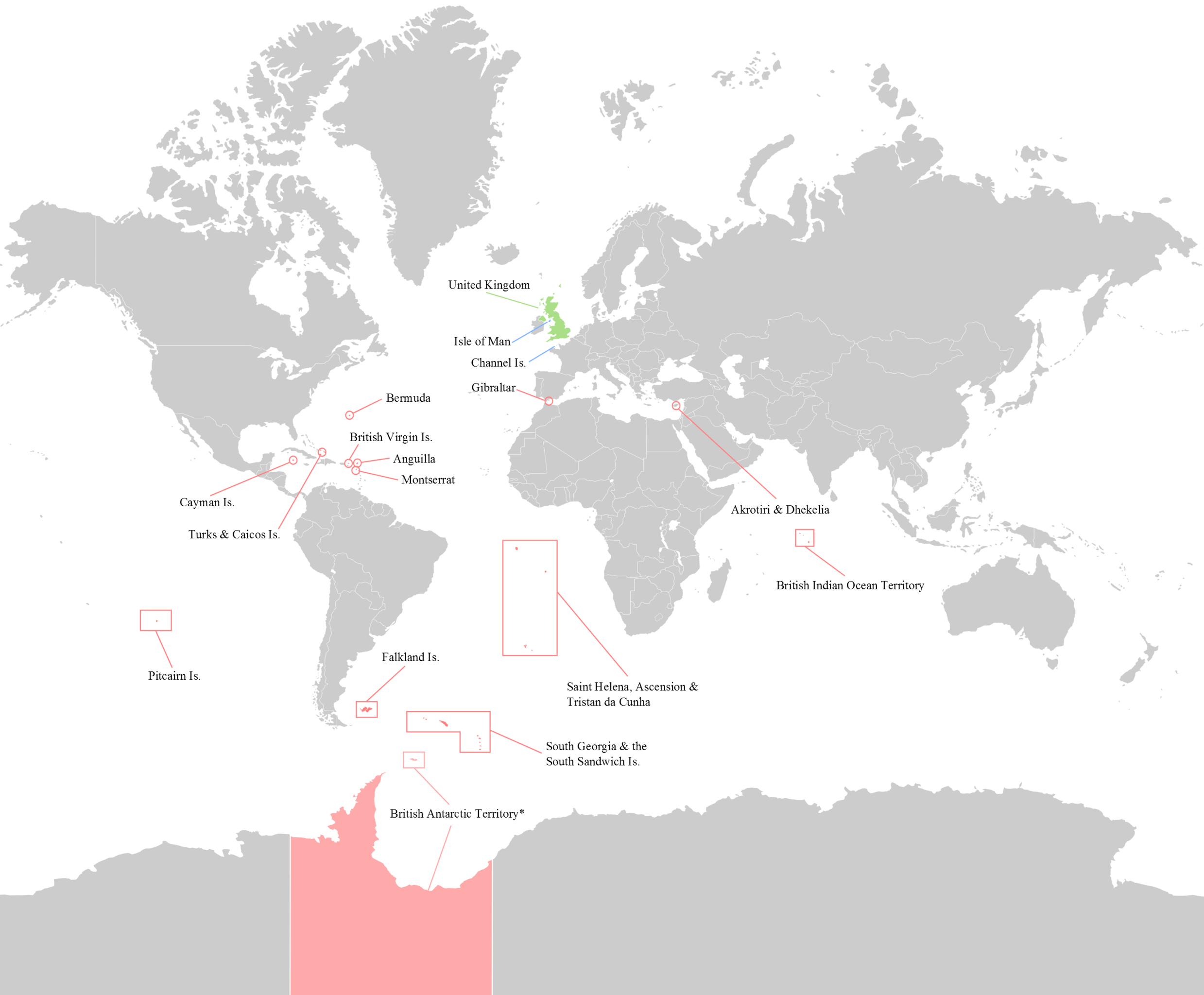
English: Map of the 14 current (2012) British Overseas Territories. Antarctica - where sovereignty is suspended is slightly lighter.
British Overseas Territories United Kingdom Crown Dependencies |
| ତାରିଖ | |
| ମୂଳାଧାର | ଆପଣା କାମ |
| ଲେଖକ | George Bozanko |

|
This locator map image could be re-created using vector graphics as an SVG file. This has several advantages; see Commons:Media for cleanup for more information. If an SVG form of this image is available, please upload it and afterwards replace this template with
{{vector version available|new image name}}.
It is recommended to name the SVG file “British Overseas.svg”—then the template Vector version available (or Vva) does not need the new image name parameter. |
ସତ୍ଵ
ମୁଁ, ଏହି କାମର ସତ୍ଵାଧିକାରୀ, ଏଠାରେ ତଳଲିଖିତ ଲାଇସେନ୍ସ ଅଧୀନରେ ଏହାକୁ ପ୍ରକାଶ କଲି:
ଏହି ଫାଇଲଟି କ୍ରିଏଟିଭ କମନ୍ସ ଅଧୀନରେ ଆଟ୍ରିବୁସନ ସେଆର-ଏଲାଇକ ୩.୦ ଅନପୋର୍ଟେଡ଼ ଲାଇସେନ୍ସରେ ପଞ୍ଜିକରଣ କରାଯାଇଅଛି ।
- ଆପଣ ଆରାମରେ:
- ବାଣ୍ଟିପାରିବେ – କାମଟିକୁ ନକଲ କରିପାରିବେ, ବାଣ୍ଟିପାରିବେ ଓ ପ୍ରସାରଣ କରିପାରିବେ
- ମିଶାଇପାରିବେ – କାମଟି ଅଭିଯୋଜନ କରିପାରିବେ
- ତଳଲିଖିତ ସର୍ତ୍ତାବଳୀ ଅଧୀନରେ:
- ଶ୍ରେୟ – ଆପଣ ମନେ କରି ଏହି କାମର ଆବଶ୍ୟକୀୟ ଶ୍ରେୟ ମୂଳ ଗଢ଼ାଳି ବା ସ୍ୱତ୍ୱାଧୀକାରୀଙ୍କୁ ଦେବେ ଏବଂ ଦେଲାବେଳେ ଲାଇସେନ୍ସର ଲିଙ୍କ ଦେଇ କି କି ବଦଳ କଲେ ଉଲ୍ଲେଖ କରିବେ । ଏହା ଉପଯୁକ୍ତ ଢଙ୍ଗରେ କରିବେ କିନ୍ତୁ ଲାଇସେନ୍ସ ଦେଉଥିବା ବ୍ୟକ୍ତି ଆପଣଙ୍କ ପ୍ରଚାର କଲା ଭଳି କିଛି ଲେଖିବେ ନାହିଁ ।
- ସେଆର ଏଲାଇକ – ଯଦି ଆପଣ ଏହି କାମଟିକୁ ବଦଳାଇବେ, ରୂପାନ୍ତରଣ କରିବେ ବା ଏହାକୁ ନେଇ କିଛି ଗଢ଼ିବେ ତେବେ ଆପଣ ଏହାକୁ ଏକା ବା ଅଲଗା ଲାଇସେନ୍ସ ଭିତରେ ରଖିପାରିବେ ।
ଫାଇଲ ଇତିହାସ
ଏହା ଫାଇଲଟି ସେତେବେଳେ ଯେମିତି ଦିଶୁଥିଲା ତାହା ଦେଖିବା ପାଇଁ ତାରିଖ/ବେଳା ଉପରେ କ୍ଲିକ କରନ୍ତୁ
| ତାରିଖ/ବେଳ | ନଖ ଦେଖଣା | ଆକାର | ବ୍ୟବହାରକାରୀ | ମତାମତ | |
|---|---|---|---|---|---|
| ଏବେକାର | ୨୧:୨୨, ୨୦ ଅଗଷ୍ଟ ୨୦୧୬ | | ୨,୭୬୮ × ୨,୨୮୮ (୪୯୧ KB) | Rob984 | Removed title, border, compass, and duplicated area at either side of the map |
| ୨୩:୫୫, ୧୦ ଅଗଷ୍ଟ ୨୦୧୪ |  | ୩,୦୦୦ × ୨,୩୦୦ (୫୪୬ KB) | RomanLier | Reverted to version as of 17:12, 3 June 2012 | |
| ୦୩:୫୨, ୧୦ ଅଗଷ୍ଟ ୨୦୧୪ |  | ୭୮୨ × ୬୦୦ (୧୪୨ KB) | RomanLier | Reverted to version as of 22:21, 9 August 2014 | |
| ୦୩:୫୧, ୧୦ ଅଗଷ୍ଟ ୨୦୧୪ |  | ୭୮୨ × ୬୦୦ (୧୪୨ KB) | RomanLier | Wrong information was corrected. | |
| ୦୩:୫୧, ୧୦ ଅଗଷ୍ଟ ୨୦୧୪ |  | ୭୮୨ × ୬୦୦ (୧୪୨ KB) | RomanLier | Wrong information was corrected. | |
| ୨୨:୪୨, ୩ ଜୁନ ୨୦୧୨ |  | ୩,୦୦୦ × ୨,୩୦୦ (୫୪୬ KB) | GBozanko | Removal of Colonial borders that were left in map after previous edit. | |
| ୧୬:୫୪, ୧ ଜୁନ ୨୦୧୨ |  | ୩,୦୦୦ × ୨,୪୦୦ (୫୫୧ KB) | GBozanko | Fix to dimensions and South Orkney colour. | |
| ୦୬:୦୯, ୧ ଜୁନ ୨୦୧୨ |  | ୩,୦୦୨ × ୨,୪୦୮ (୬୧୦ KB) | GBozanko |
ଫାଇଲ ବ୍ୟବହାର
ଏହି ସବୁପୃଷ୍ଠା ଏହି ଫାଇଲଟିକୁ ଯୋଡ଼ିଥାନ୍ତି:
ଜଗତ ଫାଇଲ ବ୍ୟବହାର
ତଳଲିଖିତ ଉଇକିସବୁ ଏହି ଫାଇଲଟିକୁ ବ୍ୟବହାର କରିଥାନ୍ତି:
- arz.wikipedia.orgରେ ବ୍ୟବହାର
- azb.wikipedia.orgରେ ବ୍ୟବହାର
- bn.wikipedia.orgରେ ବ୍ୟବହାର
- cv.wikipedia.orgରେ ବ୍ୟବହାର
- el.wikipedia.orgରେ ବ୍ୟବହାର
- en.wikipedia.orgରେ ବ୍ୟବହାର
- fr.wikipedia.orgରେ ବ୍ୟବହାର
- gl.wikipedia.orgରେ ବ୍ୟବହାର
- he.wikipedia.orgରେ ବ୍ୟବହାର
- ja.wikipedia.orgରେ ବ୍ୟବହାର
- lld.wikipedia.orgରେ ବ୍ୟବହାର
- lt.wikipedia.orgରେ ବ୍ୟବହାର
- lv.wikipedia.orgରେ ବ୍ୟବହାର
- my.wikipedia.orgରେ ବ୍ୟବହାର
- ne.wikipedia.orgରେ ବ୍ୟବହାର
- pa.wikipedia.orgରେ ବ୍ୟବହାର
- pnb.wikipedia.orgରେ ବ୍ୟବହାର
- pt.wikipedia.orgରେ ବ୍ୟବହାର
- pt.wikinews.orgରେ ବ୍ୟବହାର
- sr.wikipedia.orgରେ ବ୍ୟବହାର
- ta.wikipedia.orgରେ ବ୍ୟବହାର
- ur.wikipedia.orgରେ ବ୍ୟବହାର
- zh-yue.wikipedia.orgରେ ବ୍ୟବହାର