ଫାଇଲ:China Tibet location map.svg

ମୂଳ ଫାଇଲ (SVG ଫାଇଲ, ସାଧାରଣ ମାପ ୨,୦୧୩ × ୧,୧୩୭ ପିକ୍ସେଲ, ଫାଇଲ ଆକାର: ୪୬୫ KB)
This is a file from the Wikimedia Commons. Information from its description page there is shown below. |
ସାରକଥା
| ବିବରଣୀ |
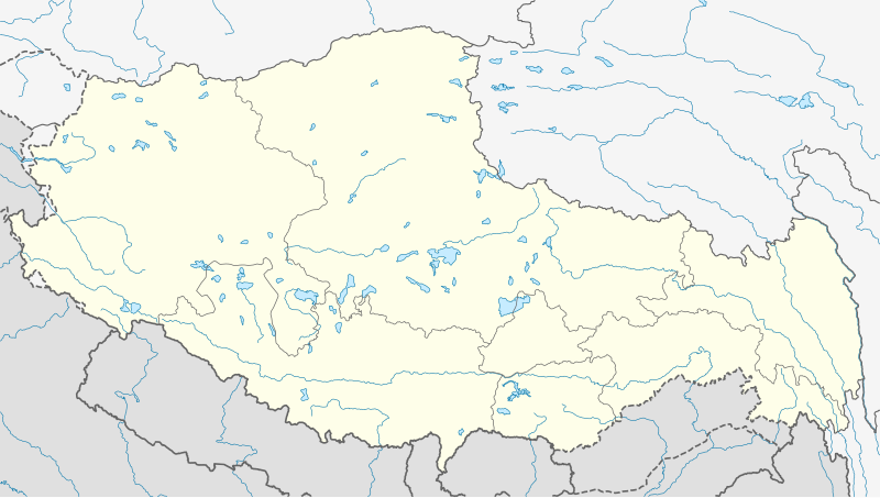
Deutsch: Positionskarte von Autonomes Gebiet Tibet, Volksrepublik China
Quadratische Plattkarte, N-S-Streckung 118 %. Geographische Begrenzung der Karte:
English: Location map of Tibet Autonomous Region, People's Republic of China
Equirectangular projection, N/S stretching 118 %. Geographic limits of the map:
|
||
| ତାରିଖ | |||
| ମୂଳାଧାର |
ଆପଣା କାମ, using
|
||
| ଲେଖକ | NordNordWest | ||
| ଅନୁମତି (ଏହି ଫାଇଲକୁ ପୁଣି ବ୍ୟବହାର କରିବେ) |
ଏହି ଫାଇଲଟି କ୍ରିଏଟିଭ କମନ୍ସ ଅଧୀନରେ ଆଟ୍ରିବୁସନ ସେଆର-ଏଲାଇକ ୩.୦ ଜର୍ମାନୀ ଲାଇସେନ୍ସରେ ପଞ୍ଜିକରଣ କରାଯାଇଅଛି ।
 ଏହି ଫାଇଲଟି କ୍ରିଏଟିଭ କମନ୍ସ ଅଧୀନରେ ଆଟ୍ରିବୁସନ ସେଆର-ଏଲାଇକ ୩.୦ ଜର୍ମାନୀ ଲାଇସେନ୍ସରେ ପଞ୍ଜିକରଣ କରାଯାଇଅଛି ।
|
||
| SVG genesis | This W3C-invalid map was created with Adobe Illustrator.
|


ଫାଇଲ ଇତିହାସ
ଏହା ଫାଇଲଟି ସେତେବେଳେ ଯେମିତି ଦିଶୁଥିଲା ତାହା ଦେଖିବା ପାଇଁ ତାରିଖ/ବେଳା ଉପରେ କ୍ଲିକ କରନ୍ତୁ
| ତାରିଖ/ବେଳ | ନଖ ଦେଖଣା | ଆକାର | ବ୍ୟବହାରକାରୀ | ମତାମତ | |
|---|---|---|---|---|---|
| ଏବେକାର | ୧୩:୫୪, ୨୨ ମଇ ୨୦୨୦ | | ୨,୦୧୩ × ୧,୧୩୭ (୪୬୫ KB) | NordNordWest | Reverted to version as of 10:41, 29 January 2019 (UTC); AGAIN: only vector data in this svg please |
| ୦୩:୦୮, ୨୨ ମଇ ୨୦୨୦ |  | ୨,୦୧୩ × ୧,୧୩୭ (୫୯୫ KB) | Geographyinitiative | Reverted to version as of 06:29, 29 January 2019 (UTC) part of Aksai Chin is under TAR jurisdiction | |
| ୧୬:୧୧, ୨୯ ଜାନୁଆରୀ ୨୦୧୯ |  | ୨,୦୧୩ × ୧,୧୩୭ (୪୬୫ KB) | NordNordWest | Reverted to version as of 12:39, 8 May 2013 (UTC); only vector data in this svg please | |
| ୧୧:୫୯, ୨୯ ଜାନୁଆରୀ ୨୦୧୯ |  | ୨,୦୧୩ × ୧,୧୩୭ (୫୯୫ KB) | 复旦大学张超 | edit | |
| ୧୮:୦୯, ୮ ମଇ ୨୦୧୩ |  | ୨,୦୧୩ × ୧,୧୩୭ (୪୬୫ KB) | NordNordWest | upd | |
| ୧୮:୦୮, ୮ ମଇ ୨୦୧୩ |  | ୨,୦୧୩ × ୧,୧୩୭ (୪୬୫ KB) | NordNordWest | upd | |
| ୧୮:୫୮, ୨୩ ଫେବୃଆରୀ ୨୦୧୦ |  | ୨,୦୧୩ × ୧,୧୩୭ (୬୩୯ KB) | NordNordWest | upd | |
| ୦୨:୧୧, ୧୧ ଡିସେମ୍ବର ୨୦୦୯ |  | ୨,୦୧୩ × ୧,୧୩୮ (୬୩୨ KB) | NordNordWest | =={{int:filedesc}}== {{Information |Description= {{de|Positionskarte von Autonomes Gebiet Tibet, Volksrepublik China}} Quadratische Plattkarte, N-S-Streckung 118 %. Geographische Begrenzung der Ka |
ଫାଇଲ ବ୍ୟବହାର
ଏହି 2 ପୃଷ୍ଠାସବୁ ଏହି ଫାଇଲ ସହ ଜଡ଼ିତ:
ଜଗତ ଫାଇଲ ବ୍ୟବହାର
ତଳଲିଖିତ ଉଇକିସବୁ ଏହି ଫାଇଲଟିକୁ ବ୍ୟବହାର କରିଥାନ୍ତି:
- ar.wikipedia.orgରେ ବ୍ୟବହାର
- ba.wikipedia.orgରେ ବ୍ୟବହାର
- be.wikipedia.orgରେ ବ୍ୟବହାର
- bg.wikipedia.orgରେ ବ୍ୟବହାର
- bn.wikipedia.orgରେ ବ୍ୟବହାର
- লোৎসে
- কৈলাস পর্বত
- ব্সাম-য়াস বৌদ্ধবিহার
- টেমপ্লেট:অবস্থান মানচিত্র চীন তিব্বত
- খ্রা-ব্রুগ বৌদ্ধবিহার
- টেমপ্লেট:অবস্থান মানচিত্র China Tibet
- র্দো-র্জে-ব্রাগ বৌদ্ধবিহার
- দ্গা'-ল্দান বৌদ্ধবিহার
- 'ব্রাস-স্পুংস বৌদ্ধবিহার
- সাঙ্গা বৌদ্ধবিহার
- মডিউল:অবস্থান মানচিত্র/উপাত্ত/চীন তিব্বত
- মডিউল:অবস্থান মানচিত্র/উপাত্ত/চীন তিব্বত/নথি
- লিপুলেখ গিরিপথ
- পুমোরি
- cdo.wikipedia.orgରେ ବ୍ୟବହାର
- ceb.wikipedia.orgରେ ବ୍ୟବହାର
- cs.wikipedia.orgରେ ବ୍ୟବହାର
- cv.wikipedia.orgରେ ବ୍ୟବହାର
- en.wikipedia.orgରେ ବ୍ୟବହାର
- eo.wikipedia.orgରେ ବ୍ୟବହାର
- es.wikipedia.orgରେ ବ୍ୟବହାର
- fa.wikipedia.orgରେ ବ୍ୟବହାର
ଏହି ଫାଇଲଟିର ଅଧିକ ବିଶ୍ୱବ୍ୟାପୀ ବ୍ୟବହାର ଦେଖନ୍ତୁ ।